|
|
Rock:Clime Beta CD Version
|


|
William J. Elliot, Project Leader U.S.D.A. Forest Service August, 2000 |
Introduction
Rock:Clime, the Rocky Mountain Research Station Weather Generator, is a web browser-based interface to the CLIGEN climate generator developed by the U.S. Department of Agriculture Agricultural Research Service (ARS) as a part of the WEPP (Water Erosion Prediction Project) computer model.� The beta test version is distributed on a CD for testing of the interface.� The CLIGEN weather generator and PRISM precipitation database incorporated into Rock:Clime are technologies which have been widely reviewed and accepted by the scientific community.
Behind Rock:Clime lies a database of more than 2600 weather stations from all 50 states, the Pacific Islands, Puerto Rico, and the Virgin Islands.� For further analysis, the PRISM database contains a grid of monthly precipitation values for a 4-km grid covering the entire continental U.S.� Also included with the PRISM database are the average elevations of each of the precipitation grid cells.� The Rock:Clime database was derived from weather station data received from the ARS Hydrology Laboratory (USDA-ARS 1999) and Oregon State University (OSU 2000).
Applications
Rock:Clime has two applications.� It can be accessed directly from the initial FS WEPP �interface screen to generate a climate file for use outside of the FS WEPP suite of interfaces, or as a secondary application through one of the WEPP:Road and Disturbed WEPP interfaces, to select a climate for that application.
Download Climate File
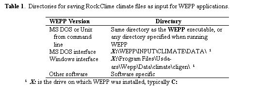
If Rock:Clime is run directly from the initial FS WEPP screen, it can generate a climate file for the climate station and number of years specified (Appendix 1 shows a sample climate file).� The file is a WEPP continuous storm *.cli file as created by CLIGEN version 4.3.� The generated climate file is downloaded and saved to the user's client computer for use by WEPP or other programs that can make use of a daily weather file.� The generated climate files are typically saved to the directories listed in table 1 for use with WEPP.
FS WEPP Applications
 Rock:Clime can be accessed from
one of the other FS WEPP programs, such as WEPP:Road
or Disturbed WEPP.� In
this application, the user accesses Rock:Clime through the �Custom Climate �button to add or remove climate stations in the
�Personal Climates� list.
Rock:Clime can be accessed from
one of the other FS WEPP programs, such as WEPP:Road
or Disturbed WEPP.� In
this application, the user accesses Rock:Clime through the �Custom Climate �button to add or remove climate stations in the
�Personal Climates� list.
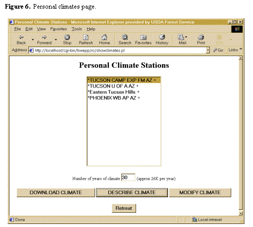
�Personal Climates� are climates which can be selected for
use in the WEPP:Road and Disturbed WEPP interfaces
in addition to the short original list of climates.� In the FS WEPP climate selection menus, personal
climates are marked with an asterisk (e.g. ![]() ).� In FS WEPP, each user can have
up to five personal climates listed.�
Climates can be added or removed from this list.
).� In FS WEPP, each user can have
up to five personal climates listed.�
Climates can be added or removed from this list.
Operation
The steps to operate the two Rock:Clime applications from a CD are listed below.� The steps are given to download a climate for use outside the FS WEPP interfaces, and to add a climate station to the FS WEPP �Personal Climates� list in WEPP:Road and Disturbed WEPP.
Download Climate File
1.
Insert the CD into the CD reader.� This is assumed to be the e:drive for these
instructions.
If:� A screen comes up stating
�The program is set to run in MS DOS Mode�Do you want to continue?�
Then:���� a.� Select �NO .
�������������� b.� Open Windows Explorer
�������������� c.� Select e:\runfsws.bat
�������������� d.� Wait while an MS DOS window appears,
followed by Web Browser interface with main
�������������� FS WEPP
screen.
Else: The FS WEPP screen will come up in a web browser.
2.
On FS WEPP screen, under Run from CD:
Click Run FS WEPP.
3.
On Forest Service WEPP Interfaces Screen:
Select desired units (� English or � Metric).
Select �Rock:Clime
.
4.
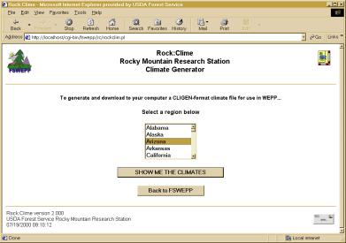
![]() Select
the desired region on the Region screen and click
Select
the desired region on the Region screen and click
�SHOW ME THE
CLIMATES .
Clicking FS WEPP Icon� or �Back to FS WEPP �returns to the FS WEPP screen.
Figure 1.� Initial Screen for running Rock:Clime from FS WEPP.�
5.
Select the nearest station to the site on the Climate
Stations screen (Figure 2).
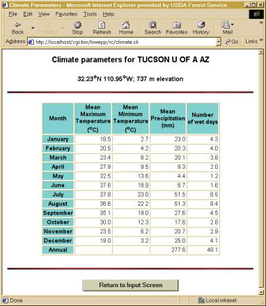
Click �DESCRIBE CLIMATE
�to View the description of the climate
if desired (Figure 3).� This screen may
help in determining the nearest station considering latitude, longitude,
elevation and precipitation amount.
Click �Return to Input Screen �when done viewing the climate description.
Figure 2.� Climate station screen in Rock:Clime.
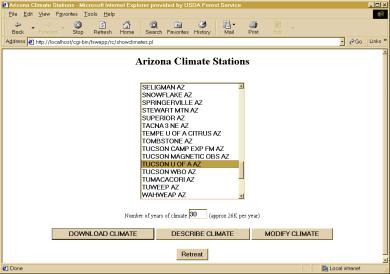
Figure 3.� Climate description screen.
6.
If the climate selected is satisfactory, go to Step
9.� Otherwise select a different
station (Step 5)
or click �Retreat
�to return to the Region
screen to select a different region (Step 4).
7.
If the climate selected needs to be modified, click �Modify Climate
.
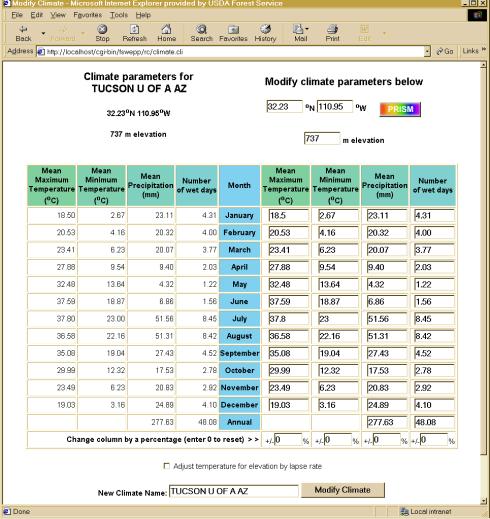
On the Modify Climate Screen (Figure 4), the values on the left side of the
table are from the CLIGEN database.� The values on the right side of the screen can be modified
either:
Manually (Step 8a)
and/or by consulting the PRISM database (Step 8b).
8a.��������� Manually
change the values on the right side of the screen if data are available.
�������������� a.� Individual monthly precipitation
amounts or numbers of wet days can be changed.
�������������� b.� The annual precipitation amount or
number of wet days can be changed,
�������������� and each monthly value will
be adjusted to maintain the same proportions.
�������������� c.� Any of the columns can increased or decreased
by a desired percentage of the CLIGEN values on
�������������� the left side of the screen
by specifying the change at the bottom of the column.�
�������������� This generally does not
work well for temperatures, as higher temperatures are
�������������� increased by a greater
amount than temperatures near zero.
�������������� d.� Temperatures can be adjusted by lapse rate
����������������������������� Enter the
elevation of the site in the box above the right side of the table.
����������������������������� Click �
adjust temperature for elevation by lapse rate below the tables.�
�������������������������������������������� Maximum
temperatures drop 6�
C per km vertical rise
�������������������������������������������� and
minimum temperatures drop 4� C per km vertical rise.
����������������������������� These are
typical values, but may be larger than observed in some geographic
����������������������������� locations
(Johnson and others 1998).
�������������� e.� When the modified climate is acceptable, click
�Modify
Climate .
�������������� f.� Go to Step 9.
Figure 4.� Rock:Clime Modify Climate screen.
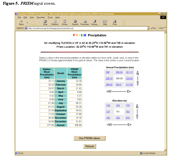
8b.��������� Access
the PRISM database for monthly precipitation amounts:
�������������� a.� Enter the desired latitude and longitude in
degrees and decimal degrees if known
����������������������������� Decimal degrees
= degrees + minutes/60 + seconds/3600
����������������������������� (Note: 0.01
degree is about 1 km or 0.6 mile).
�������������� b.� Click the �PRISM �button.
�������������� c.� Note the differences between the CLIGEN
station elevation and precipitation
�������������� and the nearest PRISM
values on the top and the table on the left side of the screen (Figure 5).
�������������� d.� The grids of values on the right of the
screen present the annual precipitation
�������������� amounts and the elevations
of the current PRISM cell (in the center) and the adjacent
�������������� cells.� The cell dimensions are 0.04 degrees or 4 km
(about 2.5 miles) in both directions.
�������������� e.� To move to another cell, click the adjacent
cell in either grid,
�������������� or return to the previous
screen and enter the desired latitude and longitude
�������������� in degrees and decimal
degrees.
�������������� f.� When the desired cell is in the center of
the grid, click �Use PRISM
values ,
�������������� or click �Retreat �to retain the original CLIGEN
values
�������������� g.� Upon returning to the Modify Climate screen,
the values in the right hand table can be manually
�������������� modified (Step 8a.).
�������������� h.� When the modified climate is acceptable,
click �Modify
Climate .
9.
When the desired climate has been selected and the region
or the personal climates screen is presented (Figure 2 or 6), select the
desired climate and specify the number of years of climate desired (1 to 200)
10. Click �DOWNLOAD CLIMATE �to generate a WEPP *.cli input file and save it on your computer
Depending on the
browser and the configuration of the user�s computer, the next screen is:
a.� A series of dialog boxes asking the
user where to save the ASCII climate file
������� �i.�� Select the desired
directory for the file (Table 1).
������� ii.�� Name the file.
���������������������� It is least
confusing to give it the same name as in the menu
���������������������� It is advantageous
to limit the length of the file name to less than 7 characters
���������������������� Specify an
extension of *.cli if the file is intended to be used with WEPP
������� iii.� Click �OK
.
Or:
b.� A browser screen containing the
climate file
������� �i.�� Under the �File �menu, select �Save As� .
������� ii.�� Select Text File (*.txt) for file type if available.
iii.� Select the desired directory for the file.
������� iv.�� Name the file.
���������������������� It is least
confusing to give it the same name as in the menu
���������������������� It is advantageous
to limit the length of the file name to less than 7 characters
���������������������� Specify an
extension of *.cli if the file is intended to be used with WEPP
������� v.� Click �Save
.
11.
Once the file has been saved:
a.� Check that the file is in the
desired directory;
b.� Change the name of the file to match
the desired name format if necessary;
�������������� WEPP requires
that climate files end with �.cli�.
c.� Check the first line of the file
matches the file description in the WEPP manual (Flanagan and
Livingston 1995, p 9).� An example of
the correct first few lines of the climate file is presented in Appendix 1.
12.
To get to the personal climate stations page (Figure 6)
directly from the Regions page (Figure 1), select �Personal �from the Region list.
13.
To delete a climate from the Personal Climate Stations
list, enter the Rock:Clime interfaces through the WEPP:Road
or Disturbed WEPP interfaces, where there is a delete button on
the Personal Climates page.� The delete
feature will be incorporated into the Rock:Clime interface.
14.
To quit the FS WEPP program when running
from a CD:
a.� Exit the web browser program running
FS WEPP.
b.� Make the MS DOS window active (by
clicking it, or by keying alt-tab until it is active).
c.� Enter Ctrl-C twice to terminate the
program.
d.� Close the MS DOS window by clicking
the upper right corner of the window.
Generate a Climate File for FS WEPP Applications
- Complete steps 1 and 2 under Download Climate File
- Select either metric or English units, and select either �WEPP:Road �or �Disturbed WEPP .
- On WEPP:Road or Disturbed WEPP, click the �Custom Climate �button.
- Follow steps 4 through 8 under Download Climate File
- Click �Return to input screen .
- Select desired climate for WEPP run.
Generated Climate File
The generated climate file is a standard WEPP multiple year continuous storm *.cli climate input file, which consists of a daily sequence of simulated representative weather for the number of years requested. The file has a ten-line header providing summary data for the file followed by one line of weather values for each day of simulation (Appendix 1 shows the beginning of a representative file).� For each day of simulation, the file contains the following information (Flanagan and Livingston 1995, p 8):
- day, month, and nominal year of simulation
- precipitation amount (mm), duration (hours), time to peak intensity (fraction of duration) and peak intensity (ratio of maximum rainfall intensity to average rainfall intensity)
- maximum and minimum temperature (�C)
- daily solar radiation (Langleys per day)
- average wind velocity (m/s)
- wind direction (degrees from North)
- dew point temperature (�C)
Each climate file contains about 26,000 bytes per year of simulation.
The CLIGEN version number (presented on the first line of the file) is set to 4.30.� Some versions of WEPP� will not recognize that CLIGEN version.� If you are in this situation, we recommend that you update your WEPP software.� In the mean time, it should be safe to edit your new CLIGEN file to report version 4.00 on the first line.
Improvements in the Rock:Clime Database
A number of errors were found in the WEPP CLIGEN database and were corrected.�
- We worked with Agricultural Research Service Water Data Center, Hydrology Laboratory personnel to realign certain shifted data in the data files used for calculating the precipitation and temperature statistics.
- We adjusted several station names to correspond to the correct station numbers based on data from the National Weather Service (NWS).
- The NWS data also were used to correct errors in elevation, latitude, longitude, and spelling.
- A record of the weather stations used for parameter interpolation, and the weighting factors, was appended to each station climate parameter file.� This information was added in the same format as the existing records for interpolation of wind data already listed in the CLIGEN parameter files.� We added records of the stations used for solar radiation and maximum half-hour precipitation, dewpoint, and time to peak.
- We increased the number of wind stations available for interpolation.
- The disproportionate maximum half-hour precipitation values for November and December in Boise, ID, were lowered.� This affected all stations that used Boise, ID for interpolating maximum half-hour precipitation.
- A maximum distance check was added to the parameter file creation program so that stations in Hawaii, Alaska, and California no longer use each other for interpolation.
- Some of the interpolation data contained zero values, which were verified to be incorrect.� For those values where we could not estimate proper values, the files were removed from the database.�
- Elevation values of zero were also checked and corrected if necessary.
- To make some of the new parameter files, several climate �storm type� values were estimated, where they were not available from the Nicks database.
Validation of Rock:Clime
Rock:Clime is an interface for the� USDA ARS CLIGEN Version 4.3 climate generator.� Version 4.3� reads individual parameter files instead of the state files which are concatenations of many parameter files but is otherwise unchanged from version 4.2 released with WEPP. There are numerous references providing validation support for CLIGEN.� These references also validate Rock:Clime because they analyze the CLIGEN algorithms rather than the database or the interface.� The PRISM database has been validated by numerous state climatologists (OSU 2000).
The technical description and validation for small watersheds for CLIGEN (Nicks and others 1995) is in the WEPP Documentation.� Nicks and Gander (1997) also performed a spatial analysis of the weather generator parameters.� Baffaut and others (1996) studied the number of years of CLIGEN simulation necessary to obtain an average erosion rate, and compared the erosivity of CLIGEN-generated climates to RUSLE erosivity values.� Elliot and others (1992) studied the suitability of CLIGEN version 1 for driving a subsurface drainage model, and determined that this early version of CLIGEN was over-predicting storm duration.� The predicted duration values have since been reduced, and Elliot and Arnold (under review) indicated that current duration values are likely to be similar to observed values.�
Arnold and Elliot (1996) found that monthly probability density functions for wet and dry spells predicted by CLIGEN were similar to observed spell lengths for lower-elevation, storm-driven climates.� CLIGEN did not perform as well for higher elevation precipitation patterns with a greater frequency of low-intensity rains.
References
Arnold, C. D. and W. J. Elliot.� 1996.� CLIGEN weather generator predictions of seasonal wet and dry spells in Uganda.� Transactions of the ASAE 39(3):969-972.
Baffaut, C., M. A. Nearing and A. D. Nicks.� 1996.� Impact of CLIGEN parameters on WEPP-predicted average annual soil loss.� Transactions of the ASAE 39(2):447-457.
Elliot, W. J. and C. D. Arnold.� (Under Review).� Validation of the weather generator CLIGEN with precipitation data from Uganda.� Transactions of the ASAE.
Elliot, W. J., W. Qiong and A. V. Elliot.� 1992.� Suitability of CLIGEN for generating rainfall data for DRAINMOD.� Applied Engineering in Agriculture 8(6):807-812.
Flanagan, D. C.� [1998]. Format of CLIGEN weather station statistics input files for Cligen version 4.1 as of 2/24/98.� : U.S. Dept. of Agriculture, Agricultural Research Service, Hydrology Laboratory.� Available online at: https://hydrolab.arsusda.gov/nicks/parameters.htm (December 1999).
Flanagan, D. C., and S. J. Livingston (eds.).� 1995.� WEPP User Summary.� NSERL Report No. 11, W. Lafayette, IN: National Soil Erosion Research Laboratory.� 131 pp.
Johnson, G. L., C. D. Daly and C. L. Hanson.� 1998.� Weather generator parameter spatial variability and mapping.� Presented at the 1998 ASAE International Meeting, Orlando, FL.� Paper No. 982006.� St. Joseph, MI: ASAE.� 5 pp.
Nicks, A. D., L. J. Lane, and G. A. Gander.� 1995.� Weather Generator.� In: Flanagan and Nearing (eds.). USDA-Water Erosion Prediction Project Hillslope Profile and Watershed Model Documentation.� NSERL Report No. 10.� W. Lafayette, IN: U.S. Dept. of Agriculture, Agricultural Research Service, National Soil Erosion Research Laboratory.
Nicks, A. D. and G. A. Gander.� 1997.� Spatial Analyses of Weather Generator Parameters.� In: Richardson, C.W., and others (eds.).� Proceedings of the Workshop on Climate and Weather Research.� Denver, CO.� July 17-19, 1995.� Washington, D.C.: U.S. Dept. of Agriculture, Agricultural Research Service. pp. 185-192.
Oregon State University (OSU)� [2000]�
Climate Mapping with PRISM.�
Available online at:�
https://www.ocs.orst.edu/prism/ .� (August,
2000).
USDA-ARS� [1999].� Arlin Nicks Climate Database.� Beltsville, MD: USDA-ARS Hydrology Laboratory, Water Data Center. Available online at: https://hydrolab.arsusda.gov/nicks/nicks.htm (December 1999).
USDA-ARS.� [n.d.].� Climate Data [�HTML document for the World Wide Web�]. In: Wepp on-line user�s guide. W. Lafayette, IN: U.S. Dept. of Agriculture, Agricultural Research Service, National Soil Erosion Research Laboratory. Available online at: https://topsoil.nserl.purdue.edu/weppdoc/ClimateData.html (December 1999).�
Appendix 1.� WEPP Climate input file
First few lines of an example .cli file created by Rock:Clime for use in WEPP.� Description of values in Flanagan and Livingston (1995) p 8-10.
4.30
�� 1��
0�� 0
�� Station:�
MOSCOW U OF I ID������������������������������ CLIGEN VERSION 4.3
�Latitude Longitude Elevation (m) Obs.
Years�� Beginning year� Years simulated
��� 46.73�
-117.00�������� 801��������� 45���������� 1������������� 30
�Observed monthly ave max temperature (C)
�� 1.4��
4.9�� 8.6� 14.0�
18.9� 23.2� 28.5�
28.4� 23.4� 15.9��
6.7�� 2.3
�Observed monthly ave min temperature (C)
� -4.9�
-2.7�� -.9�� 1.7��
4.8�� 7.7�� 9.3��
9.3�� 6.3�� 2.6��
-.9� -3.8
�Observed monthly ave solar radiation
(Langleys/day)
�122.0 214.0 338.0 479.0 571.0 618.0 672.0
565.0 420.0 247.0 136.0� 89.0
�Observed monthly ave precipitation (mm)
� 75.4�
57.0� 55.1� 51.2�
56.7� 46.4� 21.3�
26.8� 29.0� 47.2�
78.8� 75.5
�da mo year�
prcp� dur�� tp����
ip� tmax� tmin�
rad� w-vl w-dir� tdew
������������ (mm)� (h)�������������� (C)�� (C) (l/d) (m/s)(Deg)�� (C)
� 1�
1��� 1�� 8.8� 2.42� .01��
1.01�� -.6� -5.6�
53.� 3.0� 310.�
-3.2
� 2�
1��� 1�� 4.1� 1.64� .05��
1.01� -4.7� -9.2�
92.� 4.2� 275.�
-7.0
� 3�
1��� 1� 17.0�� .86� .16��
1.01� -2.9� -8.9 143.�
3.2� 105. -17.5
� 4�
1��� 1��� .0�� .00� .00���
.00�� 8.4� -9.9 115.�
3.3� 324. -17.0
� 5�
1��� 1� 34.1� 3.15� .06��
9.91�� 1.0��� .8�
87.� 3.9� 250.�
-2.9
� 6�
1��� 1�� 3.3� 1.91� .02��
6.32�� 6.8�� 1.9�
81.� 4.5� 265.�
-1.7
� 7�
1��� 1��� .0�� .00� .00���
.00� -2.8� -5.8 101.�
3.0�� 70.� -8.4
� 8�
1��� 1��� .0�� .00� .00���
.00�� 5.9�� -.6 146.�
2.1� 162.� -7.2
� 9�
1��� 1��� .8� 3.99� .08��
8.28�� 1.5��� .5 139.�
3.3�� 25.� -4.8
�10�
1��� 1�� 2.3� 3.68� .05��
1.01�� 3.4� -7.1 130.��
.0��� 0.� -2.8
�11�
1��� 1��� .0�� .00� .00���
.00�� 3.4� -9.0 156.��
.0��� 0. -22.3
�12�
1��� 1��� .0�� .00� .00���
.00� -1.3� -8.0 179.��
.0��� 0.� -4.8
�13�
1��� 1��� .0�� .00� .00���
.00� -3.3� -6.2 117.��
.0��� 0.� -4.9
�14�
1��� 1��� .0�� .00� .00���
.00� -5.6� -6.5�
83.� 2.6� 219. -11.6
�15�
1��� 1��� .0�� .00� .00���
.00� -4.2� -5.5�
96.�� .0��� 0. -18.9
�16�
1�� �1��� .0�� .00�
.00��� .00� -2.7�
-8.0� 99.� 2.0��
85. -13.5
�17�
1��� 1��� .0�� .00� .00���
.00��� .8� -1.9 118.�
6.1� 274. -11.8
�18�
1��� 1��� .0�� .00� .00���
.00�� 2.0 -10.3 105.�� .0���
0. -13.4
�19�
1��� 1��� .0�� .00� .00���
.00�� 4.8 -10.9� 91.�
4.6� 171.� -6.7
�20�
1��� 1��� .0�� .00� .00���
.00� -8.8 -10.6 107.� 2.7�
298. -18.7
�21�
1��� 1��� .0�� .00� .00���
.00�� 6.4� -9.4�
82.� 3.5�� 84.�
-1.7
�22�
1��� 1�� 4.4� 2.07� .06��
1.01�� -.6� -1.2�
84.�� .0��� 0.�
-6.8
�23�
1��� 1� 10.6� 4.38� .01�
13.49�� 4.1�� 4.1�
89.� 2.6� 172.�
-4.8
�24�
1��� 1�� 3.6� 1.70� .02��
1.01� -1.6� -3.4 144.�
9.7� 183. -20.6
�25�
1��� 1�� 2.3� 1.15� .00��
1.01�� 5.0� -7.2 136.�
3.8�� 77.� -1.3
�26�
1��� 1�� 3.5� 3.82� .05�
30.15�� 6.2�� -.4 175.��
.4� 312.�� 2.7
�27� 1 ���1���
.0�� .00� .00���
.00� -1.4� -5.7 128.�
3.4� 187.� -3.7
�28�
1��� 1��� .0�� .00� .00���
.00�� 6.7�� 1.5 115.�
2.2� 229. -14.9
�29�
1��� 1� 14.5� 4.27� .06�
39.47� 12.9�� 1.0 149.�
5.6� 193.� -5.8
�30�
1��� 1��� .0�� .00� .00���
.00�� 2.3� -7.5 125. �2.3� 152. �
�31�
1��� 1��� .0�� .00� .00���
.00� 10.4� -6.8 120.�
4.6 �
� 1�
2��� 1��� .0�� .00� .00���
.00� -3.1� -7.1 224. �
� 2�
2��� 1�� 2.4� 1.65� .02��
1.01�� 4.6� -7.1 �
� 3�
2��� 1��� .0�� .00� .00���
.00� 12.3 �
� 4�
2��� 1��� .0�� .00� .00���
.00 �
� 5�
2��� 1��� .0�� .00� .00 �
� 6�
2��� 1��� .0�� .00 �
� 7�
2��� 1��� .0 �
� 8�
2��� 1 �
� 9� 2
�
�10 �
�