
|
|
FS WEPP
|
|---|
|
William J. Elliot, Project Leader David E. Hall, Computer Programmer/Analyst Dayna L. Scheele, Civil Engineer U.S.D.A. Forest Service Rocky Mountain Research Station and San Dimas Technology and Development Center October 1999 |
|---|
 Introduction
The initial FS WEPP screen (Figure 1) provides users with the option to select the X-DRAIN program, the WEPP:Road program, or the weather data generator, Rock:Clime.
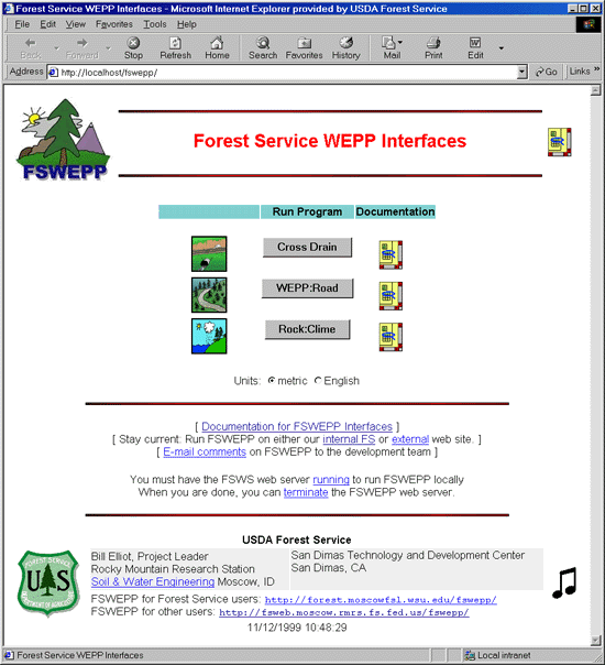
Figure 1. FS WEPP Initial Screen
The accuracy of the predicted values from X-DRAIN and WEPP:Road are, at best, within plus or minus fifty percent. True erosion rates are highly variable due to large variations in local topography, climate, soil properties, and vegetative properties, so predicted values are only a single estimate of a highly variable process.
X-DRAIN
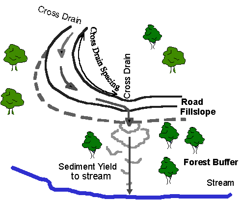
Figure 2. Template for X-DRAIN Program
With X-DRAIN, the user selects from one of 82 climates, one of five soils, one of four buffer slope steepness values, and one of five buffer lengths on the input screen (Figure 3). The sediment yield from the buffer is then presented on the results screen for 20 different sets of road gradient and cross drain spacing values (Figure 4). For example, in Figure 4, the sediment yield is 167 kg for a 60-m long road with a 4% gradient.
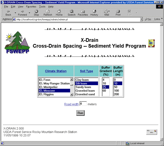
Figure 3. X-DRAIN Input Screen
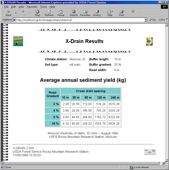
Figure 4. X-DRAIN Results Screen
X-DRAIN is useful for determining sediment yields for typical road networks to aid in road design, watershed sediment analysis, and road closure activities. It can also be applied to log landings, parking lots, and compacted trails from skidding or recreation.
WEPP:RoadOn the WEPP:Road input screen, the user can select from the short list of climates, but will likely prefer to generate a custom climate with the Rock:Clime interface to the CLIGEN weather generator. After a climate is selected, the user can select a soil, specify the road surface condition, and specify the road and buffer topographic features for slope steepnesses ranging from near zero to 100 percent, and lengths ranging from 1 m to 300 m. The user can specify the number of years of run. At least 30 years are recommended, and 50 to 100 years is preferable for climates with rainfall below 500 mm. Users must also specify the road design, select the appropriate road width and specify the presence of gravel.
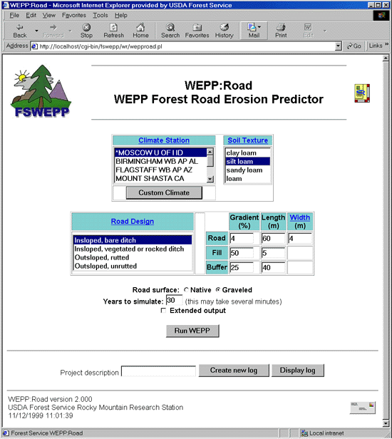
Figure 5. WEPP:Road Input Screen
The output from WEPP:Road presents not only the amount of sediment delivered from the forest buffer to a stream, but also the average precipitation, the runoff, and the amount of sediment leaving the eroding portion of the road prism. For example Figure 6 shows that for the specified conditions, the average annual values are: precipitation, 640 mm; total runoff, 0 mm; sediment leaving the road, 192 kg; and sediment delivered to the stream some 40 m below the road, 4 kg.
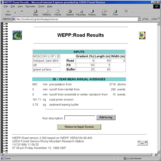
Figure 6. WEPP:Road Results screen
The results from numerous runs of WEPP:Road can be added to a log file (Figure 7) for saving or printing. For example, Figure 7 shows that for the given segment of road, gravelling reduces road erosion by 63 percent and sediment delivery by 56 percent. Outsloping the road without rutting reduces road erosion by 42 percent and eliminates all sediment delivery.
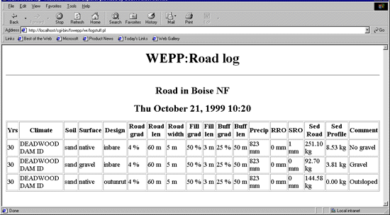
Figure 7. Example of WEPP:Road log file
Rock:ClimeRock:Clime can be accessed either from WEPP:Road or from the FS WEPP initial screen. If it is accessed from the FS WEPP initial screen, a generated climate can be saved to any directory on the user's local computer.
If Rock:Clime is accessed from within WEPP:Road (Figure 8.), the selected climate is added to the user's 'personal' climate list. Each user can have up to five personal climates at any time.
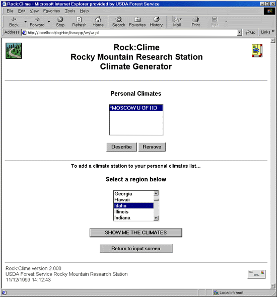
Figure 9. Rock:Clime initial screen as called from WEPP:Road
Description of WEPPThe Water Erosion Prediction Project (WEPP) soil erosion model is being developed by an interagency group of scientists including the USDA's Forest Service, Agricultural Research Service, and Natural Resources Conservation Service, and the Department of Interior's Bureau of Land Management and Geological Survey. Scientists from these agencies throughout the United States have been working since 1985 to develop WEPP to replace the Universal Soil Loss Equation (USLE).
The WEPP model is a complex computer program that describes the processes that lead to erosion. These processes include infiltration and runoff; soil detachment, transport, and deposition; and plant growth, senescence, and residue decomposition. For each day of simulation, WEPP calculates the soil water content in multiple layers and plant growth/decomposition. The effects of tillage processes and soil consolidation are also modeled.
WEPP can be run from an MS DOS set of input screens or from a Windows interface currently under development. In both versions, a set of file builders assists the user in building or altering input files which can include up to 400 input variables for a single run.
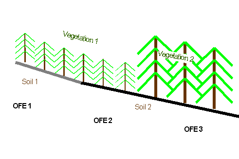
Topographic VersionsThe WEPP model is available in two versions. The base model is a hillslope version that predicts soil erosion from a single hillslope profile of any length. The hillslope can have a complex shape, and can include numerous soils and crops along the hillslope. Each unique combination of soil and vegetation is considered an overland flow element (OFE) (Figure 9). This feature of WEPP allows modeling the three-element scenario, consisting of a road, a fillslope, and a forest for the X-DRAIN and WEPP:Road programs.
The watershed version links hillslope elements of specified widths together with channel and impoundment elements.
WEPP will model basins that have a single storm basin-wide, and where upland, rather than channel, processes dominate sediment yields. For conditions where the climate is not uniform throughout the basin, or where channel sediment processes dominate the sediment budget, WEPP is not the appropriate model.
Input FilesThe slope file contains two or more sets of points describing the slope at intervals along the profile. The soil file can contain up to 10 layers of soil describing the texture and other physical properties of the soil. The most critical inputs are the erodibility and hydraulic conductivity of the surface layer.
The management file contains descriptions of each of the plant communities and descriptions of each of the tillage systems employed. The file also contains the surface condition at the start of the simulation.
Forest ApplicationsIn forests, the majority of sediment comes from forest roads, and in some conditions, from skid trails or burned areas. Our research is ongoing to improve erosion prediction in forests. A set of typical templates for the MS DOS version of WEPP for forested areas and roads is available for the hillslope version from our Internet site. Templates to accompany the Windows interface are under development.
Users are also encouraged to send comments to the FS WEPP team to be kept apprised of updates. We encourage all users to have an input into the development of more user-friendly interfaces.
For more information contact
    Peter Robichaud
    Rocky Mountain Research Station
    Moscow Forestry Sciences Laboratory
    peter.robichaud@usda.gov
    https://forest.moscowfsl.wsu.edu/engr/