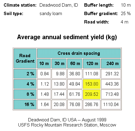
| Segment | Buffer Length (m) | Road Gradient (%) | Drain Spacing (m) | X-DRAIN Yield (kg) | Interpolated Sediment Yield (kg) |
|---|---|---|---|---|---|
| 1 | 200 | 2 4 2 4 | 60 60 120 120 | 0 0 0 0 | 0 |
| 2 | 100 | 4 8 | 60 60 | 0 0 | 0 |
| 3 | 10 | 8 16 | 120 | 210 286 | 220 |
| 4 | 10 | 4 8 | 120 | 154 210 | 182 |
| Total | 302 |
Q Find the sediment yield from a 346-m length of proposed road for the Spruce Creek Timber Sale in the Boise National Forest with the following specifications:
| Segment | Drain Spacing (m) | Road Gradient (%) | Buffer Length (m) |
|---|---|---|---|
| 1 | 90 | 3.7 | 200 |
| 2 | 56 | 5 | 140 |
| 3 | 120 | 9 | 10 |
| 4 | 120 | 6 | 10 |
| Total | 386 |
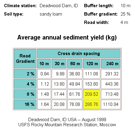
The road width is 4 m and the buffer slope is about 25 percent. The nearest available climate station is Deadwood Dam, ID. The site is on the Idaho Batholith, a coarse-grained soil most closely described as a sandy loam.
A X-DRAIN was run once for each of the three buffer lengths. Sediment yield values were interpolated for the last two road segments.
The sediment yields for segments 1 and 2 were zero for all road gradients and drain spacings for buffer lengths over 60 m.
The sediment yields for segments 3 and 4 were interpolated from the X-DRAIN results table. Because of the variability of soil erosion, precise interpolation is not necessary.
| Segment | Buffer Length (m) | Road Gradient (%) | Drain Spacing (m) | X-DRAIN Yield (kg) | Interpolated Sediment Yield (kg) |
|---|---|---|---|---|---|
| 1 | 200 | 2 4 2 4 | 60 60 120 120 | 0 0 0 0 | 0 |
| 2 | 100 | 4 8 | 60 60 | 0 0 | 0 |
| 3 | 10 | 8 16 | 120 | 210 286 | 220 |
| 4 | 10 | 4 8 | 120 | 154 210 | 182 |
| Total | 302 |
The total estimated sediment yield from this particular road section is 302 kg, from the two segments nearest the stream. From these results, the road designer may target mitigation measures to reduce sedimentation from those segments near the stream. Such measures might include outsloping, adding gravel to the travelled way, or reducing cross drain spacing from 120 m to 60 m or less.