

|
|
Rock:Clime
|
|---|
|
William J. Elliot, Project Leader Dayna L. Scheele, Civil Engineer David E. Hall, Computer Programmer/Analyst U.S.D.A. Forest Service Rocky Mountain Research Station Moscow Forestry Sciences Laboratory December 1999 |
|---|
 Introduction
| Rock:Clime builds the climate files for the FS WEPP interfaces to the WEPP model. |
Behind Rock:Clime lies a database of more than 2,600 weather stations from all 50 states, the Pacific Islands, Puerto Rico, and the Virgin Islands. The climate database was derived from weather station data received from the ARS Hydrology Laboratory (USDA-ARS 1999).
ApplicationsDownload climate file
If Rock:Clime is run directly from the initial FS WEPP screen, it can generate a climate file for the climate station and number of years specified. Appendix 2 shows a sample climate file. The file is a WEPP continuous storm .cli file as created by CLIGEN version 4.3. The generated climate file is downloaded and saved to the user's client computer for use by WEPP or other programs that can make use of a daily weather file.WEPP users will find this application to be useful because of the significant increase in the number of climates available from Rock:Clime (2,600) over that in the WEPP distribution (1,200). Of equal import is that the data for many of the stations distributed with the ARS version of WEPP contained minor errors, and many of these errors have been corrected for Rock:Clime (see Improvements in Database). The climate files generated by Rock:Clime should more accurately represent observed weather patterns.
The generated climate files typically should be saved to the directories listed in table 1 for use with WEPP.
Table 1. Directories for saving Rock:Clime climate files as input for WEPP applications. WEPP Version Directory MS DOS or Unix
from command lineSame directory as the WEPP executable, or any directory specified in command file running WEPP or manually entered MS DOS interface X:\WEPP\INPUT\CLIMATE\DATA\ * Windows interface X:\Program Files\Usda-ars\Wepp\input\climate\cligen\ * * X: is the drive on which WEPP was installed, typically C: FS WEPP Applications
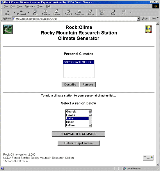
Rock:Clime can be accessed from one of the other FS WEPP programs, such as WEPP:Road. In this application, the user runs Rock:Clime through the "Custom Climate" button to view a summary of the climate data for a selected station or to add or remove climate stations in the "personal climates" list."Personal climates" are climates associated with an individual user's computer which can be selected for use in WEPP:Road and the other FS WEPP interfaces in addition to the short original list of climates. In the FS WEPP climate selection menus, personal climates are marked with an asterisk (e.g. * TELLURIDE CO). In WEPP:Road, each user can have up to five personal climates listed. Climates can be added to or removed from this list at any time.
The steps to operate the two Rock:Clime applications are listed first. These steps are followed by detailed discussion about each of the screens.
Download Climate File
- Select Rock:Clime on the FS WEPP screen
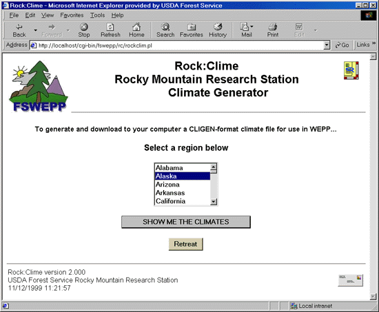
- Select the desired region on the Region screen (figure 1) and click

[Clicking the FS WEPP graphicor
returns to the FS WEPP screen]
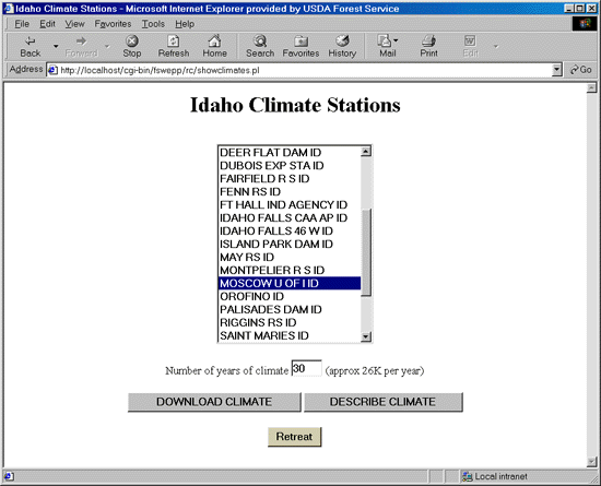
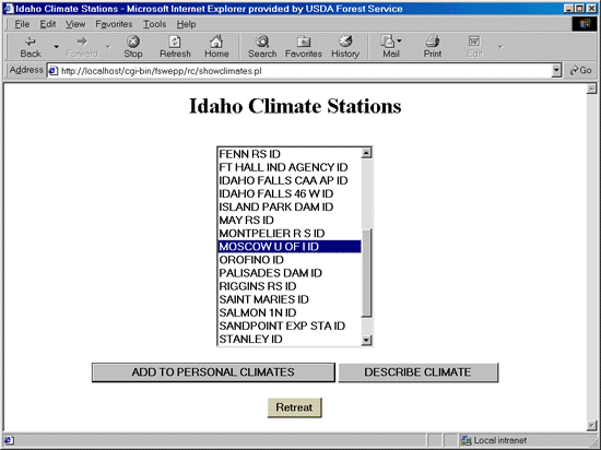
- Select the desired station on the Climate Stations screen (figure 2)
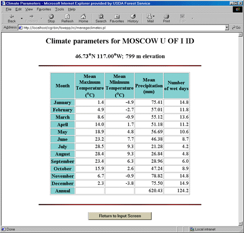
Clickto view the description of the climate if desired (figure 3)
[Clickwhen done viewing description]
[Click- Specify the number of years of climate desired (1 to 200)
- Click
to save the climate
[The browser should display a file download dialog box]- Click "OK" to

- Select the desired directory (table 1).
- Give the climate the desired name, generally 8 or fewer text and number characters followed by ".cli" Some browsers add an extra extension to the file name. Check whether this has happened (and correct it if necessary) with Windows Explorer or another file management program.
- Click "Save"
- Click "Close"
Figure 1. Initial Screen for running Rock:Clime from FS WEPP.
Figure 2. Climate station screen in Rock:Clime.
Figure 3. Climate description screen.
FS WEPP Application
- Click
on the WEPP:Road input screen
- Currently, the FS WEPP applications allow the user five "personal climates." The user may manage this list by adding or removing climates. If a sixth personal climate is requested, one of the existing five climates will be replaced with the new climate (figure 4).
- Select a climate
- Click
to view the climate description (figure 3), or
clickto remove it from the list
- Select the desired region on the initial screen (figure 4) and
- click
Clickingin the upper left corner instead returns to the WEPP:Road screen
- Select the desired station on the Climate Stations screen (figure 5)
Click
Click
Click- Click
to add the selected station
- Repeat steps 2 through 5 to make a list of up to 5 personal climates for simulation.
- Click
Figure 4. Initial screen when accessed from an FS WEPP application
Figure 5. Climate selection screen when accessing Rock:Clime from an FS WEPP application
Screen Descriptions
On the initial screen, the user can scroll through the list of regions to select the desired state or island group. Clicking the "SHOW ME THE CLIMATES" button accesses the Climate Station Screen for the selected region (figure 2). The user must select a station and specify the number of years of climate desired. For climates with more than 500 mm (20 in.) of precipitation, 30 years are generally adequate. For climates with less than 500 mm of precipitation, 50 or more years of climate may be necessary to capture the high variability of rainfall associated with drier climates (Baffaut and others 1996).
Sometimes the closest climate may not be the best descriptor for a given site. The user may wish to compare several climates to determine which climate best suits the site. The station latitude, longitude, and elevation, and the monthly average values for maximum and minimum temperature, precipitation amount, and number of wet days can be viewed by clicking "DESCRIBE CLIMATE" (figure 3). The units will be degrees Fahrenheit and inches or degrees Celsius and millimeters according to the units selection made on the FS WEPP screen.
If Rock:Clime is called from within WEPP:Road (by clicking on the "Custom Climate" button), or from within other FS WEPP interfaces, the initial Rock:Clime screen will be different than it is when Rock:Clime is called directly (figure 4). This FS WEPP application interface works in the same way as does the direct application screen with the addition of the ability to manage the 'personal climates' stored on the server. This option is not available if Rock:Clime is not started from within another FS WEPP application. An asterisk beside the station name indicates that the climate is a personal climate stored on the FS WEPP server under the user's computer name. This is consistent with the display in WEPP:Road where the stations with asterisks are personal climates and the stations without are the stock climates.
When Rock:Clime is run from an FS WEPP application, Rock:Clime will not ask for the number of years of simulation. Instead, the number of years of simulation is specified on the FS WEPP application screen.
After a new climate has been generated, the browser's "back" button should not be used to return to WEPP:Road, because that will simply redisplay the WEPP:Road screen as it was before changes were made. If the previous climate list is displayed, return to the FS WEPP screen, and rerun WEPP:Road. (The browser "refresh" or "reload" button will not work here for the stand-alone version.)
The Rock:Clime Database
The station identification includes
The precipitation and temperature data are from 40 or more years of weather records at the named station. The remaining climate statistics are estimated from sets of data with fewer weather stations and for generally shorter periods of record (Nicks and others 1995). For each named station, the two or three "nearby" stations with more detailed information for a given statistic were selected to estimate the appropriate values for the named station using weighted averages. The "nearby" stations are selected according to distance and position relative to the desired station using methods similar to those which created the original CLIGEN parameter files for WEPP (Jane Thurman, personal communication, ARS Water Data Center, Beltsville, MD). The weighting factors are part of the Rock:Clime data base which can be viewed with a text editor with the standalone version of FS WEPP, but are not accessible from the network sites. The path name to the database on the standalone version is:
X:\fswepp\cgi-bin\fswepp\rc\ID\where X: is the drive containing the FS WEPP program (usually C: or D:), and ID is the desired state. The key to the station codes (matching station name to station identification number and file name) is contained in the file named ID_climates in each state directory. The last few lines of appendix 1 are an example of the weighted average report.
Generated Climate File
For each day of simulation, the file contains the following information (Flanagan and Livingston 1995):
The CLIGEN version number (presented on the first line of the climate file) is set to 4.30. Some versions of WEPP will not recognize that CLIGEN version. If you are in this situation, we recommend that you update your WEPP software. In the mean time, it should be safe to edit your new CLIGEN file to report version 4.00 on the first line.
Improvements in the Rock:Clime Database
Validation of Rock:Clime
The technical description and validation for small watersheds for CLIGEN (Nicks and others 1995) is in the WEPP Documentation. Nicks and Gander (1977) also performed a spatial analysis of the weather generator parameters. Baffaut and others (1996) studied the number of years of CLIGEN simulation necessary to obtain an average erosion rate, and compared the erosivity of CLIGEN-generated climates to RUSLE erosivity values. Elliot and others (1992) studied the suitability of CLIGEN version 1 for driving a subsurface drainage model, and determined that this early version of CLIGEN was over-predicting storm duration. The predicted duration values have since been reduced, and Elliot and Arnold (under review) indicated that current duration values are likely to be similar to observed values. Arnold and Elliot (1996) found that monthly probability density functions for wet and dry spells predicted by CLIGEN were similar to observed spell lengths for lower-elevation, storm-driven climates. CLIGEN did not perform as well for higher elevation precipitation patterns with a greater frequency of low-intensity rains.
Climate file life expectancy
For network users, a user's "personal climates" for the FS WEPP programs are stored on the server and are associated with the user by the Internet Protocol (IP) address of his or her machine. The user can expect that the personal climate files may be purged on the server from time to time, but that they will generally be available for at least a week after creation.
Future work
References
Baffaut, C., M. A. Nearing and A. D. Nicks. 1996. Impact of CLIGEN parameters on WEPP-predicted average annual soil loss. Transactions of the ASAE 39(2):447-457.
Elliot, W. J. and C. D. Arnold. (Under Review). Validation of the weather generator CLIGEN with precipitation data from Uganda. Transactions of the ASAE.
Elliot, W. J., W. Qiong and A. V. Elliot. 1992. Suitability of CLIGEN for generating rainfall data for DRAINMOD. Applied Engineering in Agriculture 8(6):807-812.
Flanagan, D. C. [1998]. Format of CLIGEN weather station statistics input files for Cligen version 4.1 as of 2/24/98. Beltsville, MD: USDA-ARS Hydrology Laboratory, Water Data Center. Available online at: https://hydrolab.arsusda.gov/nicks/parameters.htm (December 1999).
Nicks, A. D., L. J. Lane, and G. A. Gander. 1995. Weather Generator. In: Flanagan and Nearing (eds.). USDA-Water Erosion Prediction Project Hillslope Profile and Watershed Model Documentation. NSERL Report No. 10. W. Lafayette, IN: U.S. Dept. of Agriculture, Agricultural Research Service, National Soil Erosion Research Laboratory.
Nicks, A. D. and G. A. Gander. 1997. Spatial Analyses of Weather Generator Parameters. In: Richardson, C.W., and others (eds.). Proceedings of the Workshop on Climate and Weather Research. Denver, CO. July 17-19, 1995. Washington, D.C.: U.S. Dept. of Agriculture, Agricultural Research Service. pp. 185-192.
USDA-ARS. [1999]. Arlin Nicks Climate Database. Beltsville, MD: USDA-ARS Hydrology Laboratory, Water Data Center. Available online at: https://hydrolab.arsusda.gov/nicks/nicks.htm (December 1999).
USDA-ARS. [n.d.]. Climate Data ["HTML document for the World Wide Web"]. In: Wepp on-line user's guide. W. Lafayette, IN: U.S. Dept. of Agriculture, Agricultural Research Service, National Soil Erosion Research Laboratory. Available online at: https://topsoil.nserl.purdue.edu/weppdoc/ClimateData.html (December 1999).
Appendix 1. Contents of a CLIGEN Parameter File
MOSCOW U OF I ID                        106152 0
 LATT=  46.73 LONG=-117.00 YEARS= 45. TYPE= 3
 ELEVATION = 2630. TP5 =  .85 TP6= 1.70
 MEAN P    .20   .19   .16   .18   .21   .21   .20   .22   .19   .21   .21   .20
 S DEV P   .23   .21   .17   .21   .25   .25   .22   .31   .21   .23   .24   .23
 SKEW  P  1.96  2.44  2.03  2.03  2.29  2.49  1.67  3.20  2.26  2.07  2.47  2.20
 P(W/W)    .63   .63   .64   .58   .54   .51   .36   .40   .52   .55   .66   .62
 P(W/D)    .34   .27   .28   .25   .24   .20   .10   .11   .12   .18   .33   .35
 TMAX AV 34.44 40.84 47.56 57.12 65.99 73.75 83.26 83.15 74.17 60.55 44.07 36.20
 TMIN AV 23.22 27.14 30.36 35.06 40.59 45.88 48.71 48.75 43.35 36.69 30.44 25.14
 SD TMAX  9.40  8.28  8.02  9.05  9.69  9.12  8.24  8.82 10.33 10.15  8.59  8.59
 SD TMIN  9.84  8.29  6.51  6.15  6.61  6.30  6.23  6.30  6.89  7.27  7.96  8.87
 SOL.RAD  122.  214.  338.  479.  571.  618.  672.  565.  420.  247.  136.   89.
 SD SOL   28.5  31.4  41.6  50.7  63.5  67.0  37.6 105.2  54.8  33.0  30.1  30.0
 MX .5 P   .10   .11   .10   .16   .31   .32   .53   .37   .36   .14   .13   .12
 DEW PT  20.08 26.49 27.20 31.66 39.18 44.30 44.11 43.89 41.18 37.96 31.49 26.62
Time Pk   .854  .921  .935  .944  .950  .952  .952  .956  .958  .966  .980 1.000
% N       1.93  2.15  2.40  2.85  3.88  4.99  5.89  4.62  3.65  2.87  2.16  1.80
MEAN      2.40  2.56  2.84  2.87  2.90  2.95  2.93  2.64  2.63  2.57  2.37  2.40
STD DEV   1.15  1.18  1.19  1.22  1.27  1.24  1.23  1.17  1.10  1.06   .84   .88
SKEW      1.19  1.90   .55   .81   .75   .76   .80   .92   .73   .87   .31   .52
% NNE     2.43  2.36  2.24  2.61  2.97  3.50  4.32  3.42  3.08  2.23  2.17  2.22
MEAN      2.65  3.22  3.39  3.69  3.43  3.18  3.06  2.77  2.89  3.16  2.51  2.06
STD DEV   1.15  1.33  1.48  1.59  1.56  1.28  1.35  1.06  1.23  1.28   .83   .82
SKEW       .60   .62   .35   .95   .60   .53   .68   .66   .70   .53   .36   .46
% NE      5.52  5.69  5.99  6.27  7.36  8.11  7.90  6.67  6.87  5.52  4.94  4.70
MEAN      3.06  3.28  3.30  4.05  3.35  3.34  2.84  2.81  3.22  3.04  2.94  3.03
STD DEV   1.42  1.56  1.56  1.82  1.51  1.52  1.18  1.24  1.42  1.39  1.18  1.21
SKEW      1.18  1.30  1.02   .66   .87   .85   .68   .81  1.03   .72   .67   .64
% ENE     5.47  5.41  6.39  5.23  5.59  5.77  5.48  4.65  6.19  5.74  5.69  5.39
MEAN      3.65  4.04  3.87  4.22  3.78  3.55  3.23  3.11  3.59  3.59  3.31  3.49
STD DEV   1.63  1.66  1.57  1.71  1.48  1.38  1.28  1.22  1.37  1.50  1.38  1.25
SKEW       .65   .66   .66   .60   .58   .65   .53   .47   .62   .51   .49   .40
% E       8.96  8.80  9.23  7.84  7.35  7.68  7.94  6.99  9.31  8.87  8.82  9.54
MEAN      3.34  3.76  3.80  3.52  3.37  3.11  2.95  3.07  3.21  3.29  3.36  3.40
STD DEV   1.50  1.53  1.60  1.56  1.37  1.36  1.18  1.25  1.37  1.41  1.44  1.43
SKEW       .71   .48   .57   .81   .63   .87   .55   .65   .79   .75   .51   .44
% ESE     3.80  3.66  4.00  3.41  3.54  3.35  3.19  3.23  4.29  3.89  3.93  4.38
MEAN      3.68  3.60  3.53  3.30  3.44  3.15  2.96  3.03  3.16  3.21  3.48  3.41
STD DEV   1.73  1.36  1.46  1.28  1.32  1.24  1.10  1.13  1.18  1.26  1.52  1.50
SKEW       .77   .59   .74   .56   .68   .71   .42   .42   .35   .73   .77   .73
% SE      5.54  4.40  4.58  4.49  3.85  3.60  3.63  4.58  4.77  5.41  5.53  5.17
MEAN      3.65  3.37  3.36  3.10  2.97  2.81  2.76  2.75  2.81  2.88  3.23  3.73
STD DEV   2.02  1.62  1.47  1.27  1.25  1.17  1.18  1.13  1.09  1.17  1.56  1.98
SKEW      1.20  1.00   .96   .85   .90   .64   .57   .69   .75   .98  1.12  1.14
% SSE     4.58  4.15  3.88  3.26  3.45  2.69  2.41  3.28  3.17  4.45  4.86  5.05
MEAN      4.31  3.98  3.40  3.25  3.09  2.97  2.85  2.86  2.89  3.11  3.56  4.17
STD DEV   2.38  2.09  1.58  1.32  1.21  1.26  1.10  1.15  1.09  1.34  1.82  2.30
SKEW      1.29  1.18   .98  1.24   .80   .94   .99   .87   .81   .99  1.48  1.09
% S      11.65 10.87  8.33  6.77  6.54  6.18  5.16  6.63  5.85  8.36  9.94 11.35
MEAN      4.82  4.46  4.07  3.57  3.36  3.26  3.09  3.06  3.15  3.53  4.27  4.76
STD DEV   2.96  2.56  2.17  1.67  1.60  1.51  1.53  1.39  1.40  1.90  2.48  2.88
SKEW       .98   .92  1.21  1.06  1.31  1.04  1.26  1.07  1.10  1.54  1.07   .96
% SSW     7.90  7.88  7.20  6.59  5.40  6.05  5.06  5.32  4.87  6.22  7.12  8.48
MEAN      6.04  6.12  5.25  4.57  3.94  3.79  3.64  3.59  3.57  4.60  5.88  6.36
STD DEV   3.23  3.22  2.80  2.09  1.77  1.55  1.70  1.76  1.44  2.48  3.33  3.49
SKEW       .57   .61   .79   .76   .70   .79   .93  1.12   .60   .93   .91   .83
% SW      8.23  8.69  8.80  8.62  6.97  6.98  6.15  6.35  6.43  7.26  7.07  6.72
MEAN      4.81  4.68  4.84  4.51  3.92  3.75  3.35  3.25  3.68  4.08  4.77  5.03
STD DEV   2.98  2.69  2.68  2.33  1.98  1.72  1.40  1.48  1.79  2.22  2.66  2.99
SKEW      1.00   .87  1.08   .94  1.01   .82   .49  1.12  1.07  1.10   .87  1.02
% WSW     3.63  4.24  5.38  6.33  4.99  4.52  4.33  3.89  4.35  3.65  4.19  4.32
MEAN      4.60  4.75  5.46  5.36  3.99  4.41  3.69  3.43  4.08  4.30  4.86  4.76
STD DEV   3.13  2.80  3.15  2.79  1.98  2.38  1.83  1.44  2.13  2.23  2.83  2.76
SKEW      1.55   .99   .74   .65  1.12  1.09  1.73   .67  1.11   .97   .97   .90
% W       6.18  7.70  8.67  8.98  7.89  6.27  5.57  6.52  6.73  5.75  5.98  6.33
MEAN      3.95  4.56  5.19  4.84  4.16  3.93  3.77  3.65  4.01  3.96  4.22  4.46
STD DEV   2.53  2.84  2.96  2.69  2.26  2.10  2.07  1.97  2.24  2.40  2.75  2.77
SKEW      1.50  1.17   .72   .88   .95  1.01  1.15  1.23  1.04  1.18  1.13   .96
% WNW     3.36  4.53  5.11  6.84  6.57  5.56  5.86  6.94  5.81  4.30  4.00  3.34
MEAN      4.33  4.60  5.09  5.15  4.69  4.59  4.54  4.23  4.56  4.34  4.44  4.00
STD DEV   2.31  2.49  2.52  2.49  2.30  2.30  2.23  2.01  2.22  2.30  2.58  2.12
SKEW       .83   .90   .63   .63   .73   .86   .62   .82   .83   .90   .88   .92
% NW      3.19  3.49  4.12  5.50  7.14  7.98  9.23  9.82  7.01  4.46  4.00  2.78
MEAN      3.05  3.56  4.07  4.04  3.99  3.88  3.94  3.82  3.81  3.23  3.26  3.09
STD DEV   1.65  1.93  2.13  1.99  1.94  1.87  1.86  1.82  1.97  1.59  1.90  1.66
SKEW       .99  1.15   .78   .78   .85   .68   .73   .69  1.01   .80  1.52  1.25
% NNW     1.02  1.16  1.64  1.89  2.56  3.11  3.57  3.46  2.32  1.65  1.25   .88
MEAN      2.64  2.99  3.50  3.60  3.63  3.60  3.60  3.46  3.30  3.03  2.75  2.61
STD DEV   1.16  1.30  1.71  1.69  1.72  1.46  1.60  1.63  1.59  1.29  1.22  1.05
SKEW       .81   .96   .93   .85   .82   .69   .73   .77   .90   .88  1.51  1.10
CALM     16.59 14.81 12.07 12.46 13.98 13.65 14.25 13.55 15.36 19.26 18.28 17.63

INTERPOLATED DATA (station & weighting factor)

---Wind Stations---
LEWISTON      ID     .599  SPOKANE       WA     .220  MULLAN PASS   ID     .181
---Solar Radiation and Max .5 P Stations---
 SPOKANE, WASHINGTO  .499   MEACHUM, OREGON     .304   KALISPELL, MONTANA  .197
---Dewpoint Stations---
ID LEWISTON          .648  WA SPOKANE           .239  MT MISSOULA          .113
---Time Peak Stations---
MOSCOW 5 NE ID       .782  DWORSHAK FSH HTRY I  .129  DAYTON 2 SE WA       .088
Appendix 2. WEPP climate input file
4.30
   1   0   0
   Station:  MOSCOW U OF I ID                               CLIGEN VERSION 4.3
 Latitude Longitude Elevation (m) Obs. Years   Beginning year  Years simulated
    46.73  -117.00         801          45           1              30
 Observed monthly ave max temperature (C)
   1.4   4.9   8.6  14.0  18.9  23.2  28.5  28.4  23.4  15.9   6.7   2.3
 Observed monthly ave min temperature (C)
  -4.9  -2.7   -.9   1.7   4.8   7.7   9.3   9.3   6.3   2.6   -.9  -3.8
 Observed monthly ave solar radiation (Langleys/day)
 122.0 214.0 338.0 479.0 571.0 618.0 672.0 565.0 420.0 247.0 136.0  89.0
 Observed monthly ave precipitation (mm)
  75.4  57.0  55.1  51.2  56.7  46.4  21.3  26.8  29.0  47.2  78.8  75.5
 da mo year  prcp  dur   tp     ip  tmax  tmin  rad  w-vl w-dir  tdew
             (mm)  (h)               (C)   (C) (l/d) (m/s)(Deg)   (C)
  1  1    1   8.8  2.42  .01   1.01   -.6  -5.6  53.  3.0  310.  -3.2
  2  1    1   4.1  1.64  .05   1.01  -4.7  -9.2  92.  4.2  275.  -7.0
  3  1    1  17.0   .86  .16   1.01  -2.9  -8.9 143.  3.2  105. -17.5
  4  1    1    .0   .00  .00    .00   8.4  -9.9 115.  3.3  324. -17.0
  5  1    1  34.1  3.15  .06   9.91   1.0    .8  87.  3.9  250.  -2.9
  6  1    1   3.3  1.91  .02   6.32   6.8   1.9  81.  4.5  265.  -1.7
  7  1    1    .0   .00  .00    .00  -2.8  -5.8 101.  3.0   70.  -8.4
  8  1    1    .0   .00  .00    .00   5.9   -.6 146.  2.1  162.  -7.2
  9  1    1    .8  3.99  .08   8.28   1.5    .5 139.  3.3   25.  -4.8
 10  1    1   2.3  3.68  .05   1.01   3.4  -7.1 130.   .0    0.  -2.8
 11  1    1    .0   .00  .00    .00   3.4  -9.0 156.   .0    0. -22.3
 12  1    1    .0   .00  .00    .00  -1.3  -8.0 179.   .0    0.  -4.8
 13  1    1    .0   .00  .00    .00  -3.3  -6.2 117.   .0    0.  -4.9
 14  1    1    .0   .00  .00    .00  -5.6  -6.5  83.  2.6  219. -11.6
 15  1    1    .0   .00  .00    .00  -4.2  -5.5  96.   .0    0. -18.9
 16  1    1    .0   .00  .00    .00  -2.7  -8.0  99.  2.0   85. -13.5
 17  1    1    .0   .00  .00    .00    .8  -1.9 118.  6.1  274. -11.8
 18  1    1    .0   .00  .00    .00   2.0 -10.3 105.   .0    0. -13.4
 19  1    1    .0   .00  .00    .00   4.8 -10.9  91.  4.6  171.  -6.7
 20  1    1    .0   .00  .00    .00  -8.8 -10.6 107.  2.7  298. -18.7
 21  1    1    .0   .00  .00    .00   6.4  -9.4  82.  3.5   84.  -1.7
 22  1    1   4.4  2.07  .06   1.01   -.6  -1.2  84.   .0    0.  -6.8
 23  1    1  10.6  4.38  .01  13.49   4.1   4.1  89.  2.6  172.  -4.8
 24  1    1   3.6  1.70  .02   1.01  -1.6  -3.4 144.  9.7  183. -20.6
 25  1    1   2.3  1.15  .00   1.01   5.0  -7.2 136.  3.8   77.  -1.3
 26  1    1   3.5  3.82  .05  30.15   6.2   -.4 175.   .4  312.   2.7
 27  1    1    .0   .00  .00    .00  -1.4  -5.7 128.  3.4  187.  -3.7
 28  1    1    .0   .00  .00    .00   6.7   1.5 115.  2.2  229. -14.9
 29  1    1  14.5  4.27  .06  39.47  12.9   1.0 149.  5.6  193.  -5.8
 30  1    1    .0   .00  .00    .00   2.3  -7.5 125.  2.3  152. ...
 31  1    1    .0   .00  .00    .00  10.4  -6.8 120.  4.6 ...
  1  2    1    .0   .00  .00    .00  -3.1  -7.1 224. ...
  2  2    1   2.4  1.65  .02   1.01   4.6  -7.1 ...
  3  2    1    .0   .00  .00    .00  12.3 ...
  4  2    1    .0   .00  .00    .00 ...
  5  2    1    .0   .00  .00 ...
  6  2    1    .0   .00 ...
  7  2    1    .0 ...
  8  2    1 ...
  9  2 ...
 10 ...
...
)
)
)
)
)