

|
|
WEPP:Road (Draft 12/1999)
|
|---|
|
William J. Elliot, Project Leader David E. Hall, Computer Programmer/Analyst Dayna L. Scheele, Civil Engineer U.S.D.A. Forest Service Rocky Mountain Research Station and San Dimas Technology and Development Center December 1999 |
|---|
 WEPP:RoadIntroduction
WEPP:Road is designed to predict runoff and sediment yield from:
One of the most common forest road conditions leading to sedimentation of streams is shown in figure 1, where a forest road experiences erosion between cross drains. The runoff from the cross drain is routed over the fill slope and across a buffer area to the stream.
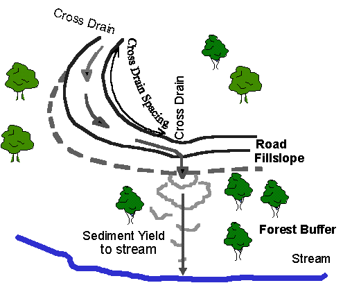
Figure 1. Relationship of road, fillslope, forest buffer and stream for the WEPP:Road Program
The WEPP ModelWEPP simulates the conditions that impact erosion--such as the amount of vegetation canopy, the surface residue, and the soil water content for every day in a multiple-year run. For each day that has a precipitation event, WEPP determines whether the event is rain or snow, and calculates the infiltration and runoff. If there is runoff, WEPP routes the runoff over the surface, calculating erosion or deposition rates for at least 100 points on the hillslope. It then calculates the average sediment yield from the hillslope.
| The WEPP:Road template has three overland flow elements: a road, a fillslope, and a forested buffer. |
The WEPP model allows a hillslope to be divided into segments with similar soils and vegetation, called overland flow elements. For the scenario shown in figure 1, WEPP:Road assumes there are three overland flow elements: a road, a fillslope, and a forest.
WEPP consists of a simulation engine and an interface. WEPP was released for public use in 1995 with an MS-DOS text-based interface. Updated versions of the engine were released in 1997, 1998, and 1999. The MS-DOS interface can be used to run WEPP in a DOS window on most personal computers. The management file builder, however, can be run only with a personal computer running in DOS mode, and will not run in a DOS window. Elliot and Hall (1997) developed a set of templates for forest road applications for the MS-DOS interface.
There is also available a Windows-based interface for WEPP. Forest templates are under development for the Windows version. Both the DOS and Windows interfaces run the same WEPP engine. The interface and the format of some of the internal data files are different. Both interfaces of the WEPP computer program can be retrieved from the USDA ARS National Soil Erosion Research Laboratory web site at (https://topsoil.nserl.purdue.edu/weppmain/wepp.html).
WEPP:Road AssumptionsClimate button and use the Rock:Clime weather generator to select desired climates from the
2600 sets of climate statistics in the database.
Users may prefer to select several nearby climates to determine the sensitivity of
their site to climate effects.
Up to five sets of custom climate statistics can be selected for the WEPP:Road interface.
button and use the Rock:Clime weather generator to select desired climates from the
2600 sets of climate statistics in the database.
Users may prefer to select several nearby climates to determine the sensitivity of
their site to climate effects.
Up to five sets of custom climate statistics can be selected for the WEPP:Road interface.
| 30 years of simulation is generally adequate |
The user must specify the number of years of simulation. For climates with more than 500 mm of precipitation, 30 years of simulation is generally adequate to obtain an estimate of erosion. For drier climates, 50 or more years of simulation may be necessary to achieve an average value. In dry climates, there are more years with little or no erosion, so a greater total number of years is necessary to ensure that there have been an adequate number of wet years. Users may wish to carry out some preliminary runs for some typical local climates to determine how many years of run are necessary for their conditions to ensure a stable average erosion value. The interface limits the number of years of simulation to 200.
When the
 button is activated, the ARS CLIGEN weather generator, distributed with WEPP,
uses the climate statistics from the selected station to generate a daily weather
sequence for the number of years specified.
The WEPP model reads the generated daily weather to complete the erosion estimates.
button is activated, the ARS CLIGEN weather generator, distributed with WEPP,
uses the climate statistics from the selected station to generate a daily weather
sequence for the number of years specified.
The WEPP model reads the generated daily weather to complete the erosion estimates.
Soil TextureTo fully describe each set of soils for WEPP requires 48 soil parameter values. These values are listed in appendix 1. Further details describing these parameters are available in the WEPP Technical Documentation (Alberts and others 1995).
Table 1. Categories of Common Forest Soils in relation to WEPP:Road soils Soil type Soil Description Universal Soil Classification Clay loam Native-surface roads on shales and similar decomposing fine-grained sedimentary rock CH Silt loam Ash cap native-surface road; alluvial loess native-surface road ML,CL Sandy loam Glacial outwash areas; granitics and sand GP, GM, SW, SP Loam Glacial tills, aluvium GC, SM, SC, MH
Road DesignIf the insloped road has wheel ruts which are carrying runoff between cross drains, then the "outsloped, rutted" design may be more appropriate.
New roads or roads with ditches that are regularly bladed
Also describes road with two ditches
Rill spacing is assumed to be 4 m
Critical shear of road element is 2 N m-2
For two ditches, enter half the width of traveled way plus the width of
one ditch, and double the predicted sediment yields
Older roads with fully vegetated ditches or roads with rocked or graveled ditches
For two ditches, enter half the width of traveled way plus the width of
one ditch, and double the predicted sediment yields
Outsloped roads with ruts less than 10 mm deep
Suited for roads that are outsloped and then closed
Direction of surface runoff is determined by outslope slope and road gradient only
Rill spacing is 1 m
Interface calculates length of flow path on road and calculates an effective width of flow
Outsloped or flat roads with wheel ruts more than 10 mm deep
Insloped, rutted roads
If the length of a rut is not known, 100 m is a reasonable assumption
Rut spacing is assumed to be 2 m
For an insloped rutted road, enter the width of the road plus the ditch width
Road design and application Description Soil assumption Width selection
Insloped, bare ditch
All runoff is diverted to inside ditch
Assumes typical road erodibility values
Enter width of road traveled way plus ditch width
Insloped, vegetated or rocked ditch
All runoff is diverted to an inside ditch which has been covered in rock greater than 10 mm dia, or channel in ditch is completely vegetated
Critical shear is 10 N m-2
Enter width of road traveled way plus ditch width
Outsloped, unrutted
Road is free from ruts
Assumes typical road erodibility values.
Enter width of road traveled way
Outsloped, rutted
Runoff follows ruts for the distance entered in road length
Assumes typical road erodibility values.
Enter width of road contributing runoff to ruts.
This will generally be about 4 m
Insloped, vegetated or rocked ditch
The
"Insloped, vegetated or rocked ditch"
design option uses a critical shear for the road element of 10 N m-2.
The majority of erosion occurs on the road surface only due to raindrop splash and shallow overland flow.
The main function of the ditch is to transport the sediment eroded from the road surface.
Selecting this option will generally reduce road erosion by 50 percent to 90 percent.
For example, for established roads in Oregon, Luce and Black (1999) observed that
road segments with vegetated ditches delivered only 10 to 20 percent as much sediment as did
segments with freshly graded ditches.
Rocking or vegetating a ditch is particularly effective in reducing sediment delivery at stream crossings.
It is less effective in reducing delivery across a forested buffer where sediment transport by runoff rather
than detachment dominates the sediment delivery.
This design best models an older road where the traveled way is devoid of vegetation, but the ditches are completely covered in vegetation. It is also suited to conditions where rock or gravel is used to line the ditch to limit erosion. There may be some deposition of sediment in a vegetated ditch, but research has not been able to support this supposition. Lining a channel with rock has not been effective in causing deposition (Grace 1998).
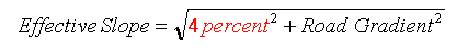
The "Outsloped, unrutted" option assumes that the road has an outslope slope of 4 percent.
The effective slope of the road is assumed to be the resolution of the road gradient and the outslope slope, calculated as
The effective length (figure 2) of the flow path over the road surface is:
In order to maintain the correct total road surface area, an effective width of the element is then calculated as
These calculations are all carried out by the WEPP:Road interface.
In order to see the calculated values, users can request the
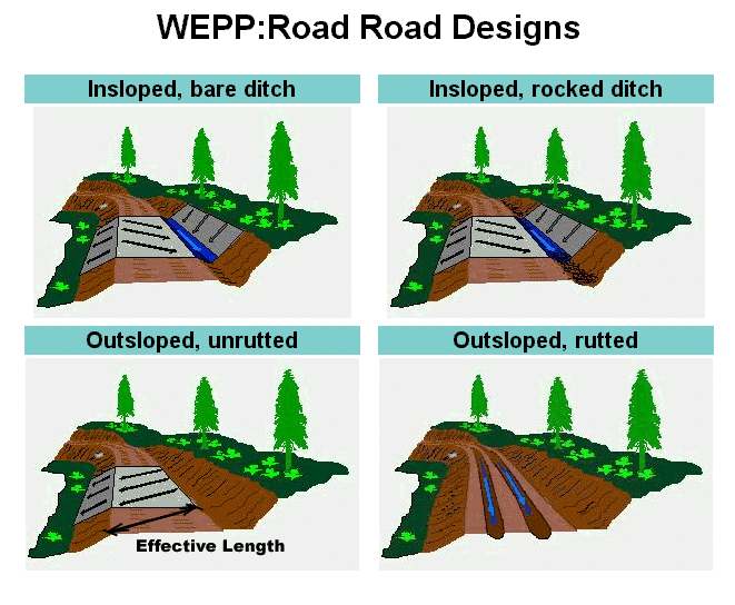
Figure 2. Diagram of flow directions for road designs in WEPP:Road program
Outsloped, unrutted
Two outsloped options are available--with and without ruts.
The "Outsloped, unrutted" design best descibes the road condition immediately following blading.
With traffic, however, wheel tracks soon begin to flatten, and runoff tends to follow wheel tracks--even if
rutting is barely discernable--from one surface cross drain to the next.
The "Outsloped, rutted" option generally is the most appropriate selection for an outsloped road.
Only in cases where a road is outsloped, and traffic is light or restricted, is the "Outsloped, unrutted"
design appropriate.
This may occur on a road that is closed, but prior to closure is bladed and outsloped.


 option on the input screen.
The EffectiveLength in meters is the length of the first overland flow element, and the EffectiveWidth is noted with the sediment yield data (appendix 2).
option on the input screen.
The EffectiveLength in meters is the length of the first overland flow element, and the EffectiveWidth is noted with the sediment yield data (appendix 2).
Outsloped, rutted
The outsloped, rutted option assumes a rill spacing of 2 m, similar to the spacing of the wheel tracks.
The user should enter the width of road contributing flow to the wheel ruts.
If there is a ditch carrying runoff and subject to erosion, then the user should include the width of the ditch as well as the road (Example 6).
The "Outsloped, rutted" design may be appropriate for an insloped road with wheel ruts which are carrying runoff between cross drains. This option specifies a rill spacing of 2 m, whereas the insloped design uses 2 m. This will change the predicted road erosion rates. The user should enter the width of the road plus the ditch.
For a crowned road, the user will need to consider both sides of the crown and one or both ditches. If there is only an uphill ditch, then half of the road width is insloped and half of the road width is outsloped. The total erosion is the sum of the insloped and outsloped erosion values. If the road has a ditch on both sides, then the road is effectively made up of two narrow insloped sections, and it can be modeled with one of the insloped designs by summing the widths of the traveled way and the ditches in the width box.
Gravel Addition .
This selection alters the soil file by increasing the rock content and the hydraulic conductivity of the soil (appendix 1).
.
This selection alters the soil file by increasing the rock content and the hydraulic conductivity of the soil (appendix 1).
The addition of gravel has two major impacts on erosion rate. Research has shown that gravel alters the hydraulic conductivity of a soil, and it changes the flow path length of the road (Foltz and Truebe 1995). Generally, the addition of gravel increases the porosity and increases the hydraulic conductivity of the road, which decreases the runoff (Flerchinger and Watts 1987).
The increase in conductivity may not result in a decrease in erosion. In areas where runoff is due to saturated conditions rather than to rainfall rates exceeding hydraulic conductivity, runoff may be similar, or even greater, following an increase in road conductivity, because the road is more likely to be saturated.
The impacts of gravel on soil properties, however, are not as important in reducing road erosion rates as is the impact of gravel on flow path length. Gravel reduces the formation of ruts (Foltz and Truebe 1995). On a gravel road that is outsloping, or that has a nonerodible ditch, the flow path is generally 10 m long. On roads without gravel where flattening or rutting of wheel tracks is common, the flow path length will be the spacing between cross drains. The reduction in flow path length with the addition of gravel is likely the reason for the 80 percent reduction in erosion often credited to the addition of gravel. Example 3 demonstrates how gravel reduces road erosion through alteration of topography.
TopographyThe topographic limitations for WEPP:Road are shown in table 3. All lengths in the WEPP model are horizontal, as would be measured directly from a contour map. WEPP adjusts the horizontal length internally to determine the true overland length. If the user has measured overland lengths during a site survey, the horizontal length can be found by multiplying the overland length by the cosine of the slope angle. The slope angle is the inverse tangent (arctangent) of the slope in decimal units (see example 1).
The effect of changes in topography tends to be consistent, so interpolation between values is acceptable. However, the effect is not linear, so extrapolation beyond predicted values is not recommended. On roads with no cross drains, flow path lengths along the road surface seldom exceed 120 m unless the road is severely rutted, or the road is insloped with a long inside ditch.
| On roads with no cross drains, flow path lengths along the road surface seldom exceed 120 m. |
To estimate the sediment delivery at a stream crossing, the user can assume that all of the road prism
erosion enters the stream.
This method does not include any erosion from the fill slope.
Alternatively, the minimum lengths can be selected for the fillslope and buffer lengths
and the sediment leaving the buffer can be used as an estimate of sediment delivery.
This method may overestimate deposition on the fill or buffer.
In some situations, runoff over the buffer may be channelized.
WEPP:Road will not predict erosion or deposition in a channel.
It will give only an estimate of the amount of sediment that was delivered to the channel.
Templates using the WEPP watershed version are under development to address this condition.
If the user is modeling narrow bicycle or foot trails, then an appropriate narrow width should be specified.
For log landings, parking lots, compacted construction sites and similar wide disturbed areas,
the width of the landing can be entered in the width box.
Variable Range of Values Road Gradient 0.1 to 40 percent Road horizontal length 1 to 300 m Road horizontal width 0.3 to 100 m Fillslope slope 0.1 to 150 percent Fillslope horizontal length 0.3 to 100 m Buffer gradient 0.1 to 100 percent Buffer horizontal length 0.3 to 300 m
The road width specification should include the width of the ditch or ditches if they are eroding.
If the road is outsloped and rutted, only that portion of the width of road contributing runoff to the
ruts should be specified.
This generally is the rut spacing plus the distance from the inside rut to the cutslope.
Road Width
Forest roads are generally 4 to 6 m wide
The most complex input file in the WEPP model is the management file, which describes the vegetation.
For the WEPP:Road program, the road has no vegetation, the fillslope has sufficient vegetation to provide
about 50 percent ground cover, and the forest buffer has a 20-year old forest with 100 percent
ground cover.
The values are similar to those described for the PLUME3 template for WEPP in Elliot and Hall (1997).
For other conditions, such as a burned buffer or vegetated road, users will have to run the WEPP model.
Management (Vegetation Cover)
If applied to skid trails or similar temporary trails, WEPP:Road can be run to determine the erosion rate for the first year. Generally, following revegetation, erosion rates rapidly decline to near zero within five years. The WEPP:Road erosion rate can be reduced by 20 percent each year for five years following the disturbance to obtain an estimate of total erosion associated with the skid trail.
If the buffer is not forested, then the user may need to consider some other tool to predict sediment delivery. The sediment yield from the road will still be correct. Further work on the WEPP:Road interface may include alternative vegetation scenarios for the buffer.
Running WEPP:Road
button.
The user also may wish to check the
box to obtain more detailed information about the distribution of erosion and deposition,
and the size distribution of the eroded sediment.
Results ScreenFigure 3 shows that the average annual precipitation for the climate selected was 823 mm per year, from a total of 3434 storms during the 30-year period simulated, which is about 100 storms per year. The average runoff from the rainfall-only events was less than 0.5 mm per storm from 40 events, and the average runoff from snowmelt, or rain-on-snow, events was 1 mm from 140 events. The average annual amount of sediment leaving the road traveled way or ditch was 18.27 kg, and the average annual amount of sediment leaving the forest buffer and entering a stream system was 4.6 kg. For many conditions, there will be some sediment delivered every year. For drier climates, the average value may include a number of years when there was little erosion, with only a few major runoff events during the period of simulation.
| The accuracy of a predicted runoff or erosion rate is, at best, plus or minus 50 percent. |
Any predicted runoff or erosion value--by any model--will be, at best, within plus or minus 50 percent of the true value. Erosion rates are highly variable, and the models predict only a single value. Replicated research has shown that observed erosion values vary widely for identical plots, and for the same plot from year to year (Elliot and others 1994; Elliot and others 1995; Tysdal and others 1999).
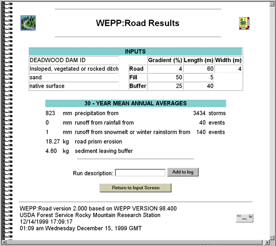
Figure 3. WEPP:Road Results screen
Extended Output Information option, additional information about the WEPP run can be obtained.
The information includes the presence and length of a sediment plume, and the size distribution of the sediment
delivered from the bottom of the hill.
The extra output is added to the bottom of the results screen and can be accessed by scrolling down the page.
An example extended output is shown in appendix 2.
WEPP predicts the size distribution of eroded sediment by dividing the sediment into sand, silt, and clay particles; small aggregates made up of organic matter, clay and silt; and large aggregates made up of organic matter, clay, silt, and sand. Typically, sand deposits first, and clay and small aggregates deposit last. At the end of the extended output is a table that shows the distribution of sediment in each of the size classes in the soil, and in the eroded sediment. Example 7 shows how to calculate the sand content from the table at the end of appendix 2.
Log File button.
The results of a run can be entered into the log table from the output screen by clicking the
button.
The results of a run can be entered into the log table from the output screen by clicking the
 button.
A run description can be entered in the run description box to assist with interpretation of the table.
Once a line is entered in the table it can not be deleted within WEPP:Road.
The user can copy the entire log page and paste it into a word processor or a spreadsheet,
and edit the output if desired.
Examples 2, 3, and 4 all contain log pages that have been copied and edited to present the desired information.
Applications
button.
A run description can be entered in the run description box to assist with interpretation of the table.
Once a line is entered in the table it can not be deleted within WEPP:Road.
The user can copy the entire log page and paste it into a word processor or a spreadsheet,
and edit the output if desired.
Examples 2, 3, and 4 all contain log pages that have been copied and edited to present the desired information.
ApplicationsThe second application of this program is to evaluate the impact of road topography on any road (including skid trails) on sediment delivery. The necessary input information is collected, and the output table is studied to determine what spacing will give an acceptable sediment yield (examples 4 and 5).
Another application is as an aid to identifying sections of road that are the best candidates for closure or for mitigation measures, making best use of limited funding (example 4).
A summary of the application of WEPP:Road to various other road designs is given in table 4.
Condition WEPP:Road application Road with flat traveled way
Enter width of traveled way in width box and read output directly Insloping road with no ditch treatment and no ruts
Enter width of traveled way plus inside ditch in width box Insloping road with rocked or graveled ditch and no ruts
Select Insloped, vegetated or rocked ditch road design and enter width of traveled way plus ditch Outsloping road without ruts
Select Outsloped, unrutted road design and enter width of traveled way Outsloping road with ruts
Select Outsloped, rutted road design and enter width of traveled way Addition of gravel
Click the button and read the "Gravel Addition" sectionCrowned road, two ditches, no ruts
Select Insloped, vegetated or rocked ditch design and specify width including both ditches
(example 6) More complex conditions
Run the WEPP model for the specific conditions
ExamplesExample 1
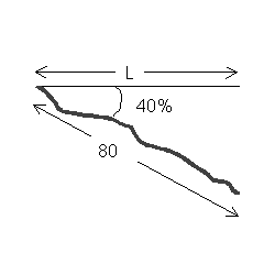
| During a site survey, the steepness of the buffer is measured with a
clinometer to be 40 percent and the overland length of the buffer
is measured with a range finder to be 80 m.
What is the horizontal length of the buffer?
Solution: |
Solution:
These results show that the second segment is not a great source of sediment, but the stream crossings
(segments 3 and 4) are.
The total sediment generated from these four problem segments is about 240 kg.
Example 3 will consider outsloping and graveling all of these problem segments to see whether sedimentation
can be reduced to an acceptable level.
The addition of gravel will help to ensure that the outslope is not lost to rutting on these sensitive
road segments.
Solution:
The total sediment from these four segments has been reduced from about 240 kg to 35 kg,
a soil loss reduction of about 85 percent due to gravel.
Reductions of this magnitude have been measured by numerous researchers including Burroughs and King (1989)
and Swift (1984a).
Solution:
Each of the three road segments is analyzed to produce the following results:
It appears that the middle road will be the best one to keep open.
The upper road, located on a steeper part of the hillside, is delivering more sediment.
Users may wish to run the WEPP model for this template to be able to describe the hillside
in greater detail than the WEPP:Road interface allows.
Solution:
The extended output from this analysis is given in appendix 2.
The third column in section C of the extended output shows the predicted deposition rates for 100 points
along the buffer.
The negative numbers in this element show "negative" erosion, or net deposition in that part of the element.
When the amount of deposition drops to 1 kg/m2 or less, the depth of deposition is less than
1 mm.
This is the extent of the sediment plume, although sediment may be carried farther.
In this example, the deposition first reaches zero at 91 m, which is 26 m from the toe of the fill.
Hence, the minimum buffer length should be at least 26 m.
Note that at even 40 m, there is still some sediment delivery to this stream.
Greater buffer lengths will likely result in less sediment delivery, but reductions in sediment delivery
will be small at buffer lengths greater than 26 m.
Solution:
The resulting predicted sediment delivery value is 1130 kg of sediment from one side of the stream intersection.
The value is doubled to an average annual value of 2260 kg of total sediment delivered from both road
segments to the stream.
Solution:
The predicted annual amount of sediment delivered is 176 kg.
The average annual amount of sand delivered is
Below fill
Example 2
An analysis of a road network in the Boise National Forest with X-DRAIN identified four road segments as the most likely sources of sediment from a given watershed.
Two of the segments are on either side of a stream crossing so the buffer distance is small.
The details of the segments are presented in the following table.
Find the sediment yield from these segments, assuming the road width is 5 m.
The buffer slope is about 35 percent.
The fillslope length is 4 m with a 50 percent slope.
The nearest climate station is Deadwood Dam.
The site is on the Idaho Batholith, a coarse-grained soil most closely described as sandy loam.
The road is well established with a vegetated ditch.
Segment Drain spacing
(m)Road gradient
(%)Buffer Length
(m)
1 90 3.7 120
2 56 5 70
3 80 9 1
4 70 6 1
A thirty-year WEPP:Road simulation was run for each of the segments, with the custom climate Deadwood Dam, ID, and
each result was entered into the log.
An abbreviated log table follows:
Surface Design Road grad Road len Road width Fill grad Fill len Buff grad Buff len RRO SRO Sed Road Sed Profile Comment
native inveg 3.7 % 90 m 5 m 50 % 4 m 35 % 120 m 0 mm 1 mm 45.87 kg 18.23 kg Segment 1
native inveg 5 % 56 m 5 m 50 % 4 m 35 % 70 m 0 mm 1 mm 23.95 kg 9.71 kg Segment 2
native inveg 9 % 80 m 5 m 50 % 4 m 35 % 1 m 4 mm 24 mm 164.67 kg 154.40 kg Segment 3
native inveg 6 % 70 m 5 m 50 % 4 m 35 % 1 m 3 mm 22 mm 56.98 kg 54.89 kg Segment 4
Example 3
What is the impact on the road segments in example 2 if the problem segments are graveled and outsloped?
If road segments 3 and 4 are outsloped, then the amount of road with only 1 m of buffer is likely to
be reduced to about 15 m for each segment.
This assumption requires field or map verification to see whether the road crossed directly over the stream as we have assumed,
or was running parallel to the stream for some distance. The buffer lengths for the remaining road segments
will be approximately 50 m for segment 3 and 45 m for segment 4.
The "graveled" button is clicked, and the shorter road lengths are specified for segments 3 and 4.
The results are entered into a log file.
The abbreviated log file shows:
Design Road grad Road len Road width Buff grad Buff len RRO SRO Sed Road Sed Profile Comment
outunrut 3.7 % 90 m 5 m 35 % 120 m 0 mm 0 mm 83.24 kg 0.86 kg Segment 1
outunrut 5 % 56 m 5 m 35 % 70 m 0 mm 0 mm 65.21 kg 1.61 kg Segment 2
outunrut 9 % 15 m 5 m 35 % 1 m 3 mm 5 mm 34.20 kg 13.09 kg Short Segment 3
outunrut 9 % 65 m 5 m 35 % 50 m 0 mm 0 mm 147.54 kg 5.62 kg Remaining Segment 3
outunrut 6 % 15 m 5 m 35 % 1 m 2 mm 4 mm 21.14 kg 7.66 kg Short Segment 4
outunrut 6 % 55 m 5 m 35 % 45 m 0 mm 0 mm 124.84 kg 5.79 kg Remaining Segment 4
Example 4
There are three old logging roads located on a hillside in the Boise National Forest with the same
climate, soil, and fillslope characteristics as in example 2.
The road traveled way is 4 m wide, and may experience some rutting.
The forest wishes to retain the lowest road possible to allow access for recreational fishing and related
wildlife administration.
They wish to put in cross drains only every 120 m to allow for ease of maintenance, and to minimize
discomfort to road users.
The gradients of all three roads are 4 percent.
The lower road is 10 m from the stream with a 10 percent buffer slope,
the middle road is 80 m from the stream with a 25 percent buffer slope,
and the upper road is 200 m from the stream with a 60 percent buffer slope.
Which road should be retained?
For a road with ruts the width will be less than 4 m because the part of the road between the
outside rut and the fillslope generally does not contribute to the rut flow.
Therefore, we will assume that the width is 3 m.
Yrs Surface Design Road width Fill grad Fill len Buff grad Buff len RRO SRO Sed Road Sed Profile Comment
30 native outrut 3 m 50 % 4 m 60 % 200 m 0 mm 1 mm 449.64 kg 21.34 kg Upper Road
30 native outrut 3 m 50 % 4 m 25 % 80 m 0 mm 1 mm 448.56 kg 13.95 kg Middle Road
30 native outrut 3 m 50 % 4 m 10 % 10 m 1 mm 11 mm 426.60 kg 62.91 kg Lower Road
Example 5
A road is in the planning stages near Charleston, WV on a site with silt loam soil.
The hillsides have slopes of about 25 percent.
The desired cross drain spacing is 60 m.
The fill has a slope of 50 percent and is 5 m long.
The road width is 4 m.
How far should the road be located from the stream to ensure that there is a minimum amount of sediment reaching the stream? Assume that the road will have a stable ditch.
The given values are entered into the WEPP:Road interface, selecting 40 m as the length of the buffer.
The
option is selected.
Example 6
A graveled county road is located near Rhinelander, WI.
It is crowned with a ditch on each side.
The ditches are vegetated.
The soil is loam.
The width of the road including both ditches is 10 m.
A segment of the road intersects a sensitive stream.
In the vicinity of the intersection,
the road gradient is 1 percent, and
the length of road contributing to the stream is 220 m from either side.
How much sediment is entering the stream from both lengths of the road?
Select Rhinelander, WI as a custom personal climate. Because the road intersects the stream, the length of the fill and buffer are set to the minimum allowable value of 0.3 m.
The gradient of the fill and buffer are set to be 1 percent--the same as the road.
The "Insloped, vegetated or rocked ditch" design option is selected, and the width is entered as 10 m.
Example 7
What is the sand content and total amount of sand in the delivered sediment from the extended output presented
in appendix 2?
The sediment size table in appendix 2 is:
Summary of size distribution of upland and eroded sediment.
The sand fraction makes up 60.1 percent of size class 4 and 100 percent of size class 5.
The total fraction of sand in the delivered sediment is
     Sediment particle information leaving profile
-------------------------------------------------------------------------------
                                 Particle Composition         Detached Fraction
Class  Diameter  Specific  ---------------------------------  Sediment  In Flow
         (mm)    Gravity   % Sand   % Silt   % Clay   % O.M.  Fraction  Exiting
-------------------------------------------------------------------------------
  1      .002      2.60       .0       .0    100.0     53.3      .039     .043
  2      .010      2.65       .0    100.0       .0       .0      .280     .299
  3      .030      1.80       .0     78.6     21.4     11.4      .270     .280
  4      .300      1.60     60.1     20.8     19.1     10.2      .278     .262
  5      .200      2.65    100.0       .0       .0       .0      .133     .116
-------------------------------------------------------------------------------
60.1% x 0.262 + 100% x 0.116 = 0.273.
This value can be compared to 0.3 as the sand fraction of a silt soil for the road element (appendix 1).
176 x 0.273 = 48 kg.
There has been no direct validation of the WEPP:Road program, and little data have been
collected on the amount of sediment that enters a stream that was detached from a road
and transported across a forested buffer.
There have been field observations on erosion rates from road surfaces and road prisms,
and on lengths of sediment plumes.
Some of these observations are presented in table 5, along with the sediment yields and
sediment plume lengths predicted by the WEPP:Road program.
Validation
Site and Ecoregion Erosion Rate
(t ha-1 yr-1)
Source
Observed at Zena Creek, ID
18
Megahan and Kidd 1972a. (Included entire new road prism. Some sediment from landslides.)
Predicted for Zena Creek, ID
8.6
Deadwood Dam, ID climate, bare ditch. Prediction for surface erosion only
Observed bare and graveled road in Southern Appalachians
11 to 150
Swift 1984a and 1984b
Predicted for Southern Appalachians
13-119
Coweeta, NC climate, Sandy loam, native outsloped with ruts and graveled outsloped unrutted
Observed for Alum Creek, AR
15 - 76
Beasley and others 1984. (Vegetated fill slope and ditch.)
Predicted for Alum Creek, AR
22, 34, 51
Clarksville, AR climate, sandy loam with gravel, insloped vegetated ditch, outsloped no ruts, and insloped bare ditch designs
Observed bare and gravelled road for Fernow NF, WV
13.5 - 118
Kochenderfer and Helvey 1987
Predicted for Fernow NF, WV
16 - 30
Clarksburg,WV climate, outsloped unrutted gravel and outsloped rutted native designs
Sediment Plume Length
(m)
Observed on Silver Creek Watershed, ID
Cross drain 11 - 183
(mean = 50)
0.4 - 66
(mean = 3.8)
Ketcheson and Megahan 1996
Observed in Nez Perce NF, Central ID
Below culverts
80 percent less than a mean of 24
Wasniewski 1994
Predicted for Silver Creek Watershed
Cross drain
Below fill
30
0.9Deadwood Dam, ID climate.
Insloped, eroding ditch design.
Distance of plume on fill, no sediment made it to the forest buffer. Outsloped, unrutted design.
Predicted for Wine Springs Watershed, NC
L = 5.1 + 0.00197 M
= 7.0
McNulty and others 1995.
L is length in meters, M is predicted sediment yield from road. Length with a WEPP:Road predicted yield of 1184 kg.
Filter strip widths in SE U.S.
13 + 0.426 x percent slope = 24
Swift 1986. Assumed slope of 25 percent.
Predicted for SE U.S.
27 - 34
For Coweeta, NC climate, graveled sandy loam soil. Outsloped unrutted, and insloped vegetated ditch designs
Observed in Tuskegee NF, AL
50 - 60
Grace 1998. Occurred Aug '97 - Jan '98
Predicted for site 45
Montgomery, AL climate, Sandy loam, minimum fillslope, 10 percent buffer gradient
References
Appendices| Element and Property | Units | Clay Loam | Silt Loam | Sandy Loam | Graveled Loam | Graveled Sand |
|---|---|---|---|---|---|---|
| Road Surface | ||||||
| Albedo of the bare soil | Fraction | 0.6 | 0.6 | 0.6 | 0.6 | 0.6 |
| Initial saturation of the soil | m m-1 | 0.5 | 0.5 | 0.5 | 0.5 | 0.5 |
| Baseline interrill erodibility (ki) | kg s m-4 | 1.50E+06 | 2.00E+06 | 2.00E+06 | 1.50E+06 | 2.00E+06 |
| Baseline rill erodibility (kr) | s m-1 | 0.0002 | 0.0003 | 0.0004 | 0.0002 | 0.0004 |
| Baseline critical shear | N m-2 | 0.04 | 0.04 | 0.04 | 0.04 | 0.04 |
| Hydraulic conductivity | mm h-1| 0.1 | 0.27 | 3.8 | 8.4 | 10.2 | |
| Depth of soil layer | mm | 200 | 200 | 200 | 200 | 200 |
| Percentage of sand | % | 30 | 30 | 60 | 35 | 70 |
| Percentage of clay | % | 30 | 15 | 5 | 30 | 5 |
| Organic matter (by volume) | % | 0.01 | 0.01 | 0.01 | 0.01 | 0.01 |
| Cation exchange capacity | Meq/100 g | 24 | 12 | 4 | 24 | 4 |
| Rock fragments (by volume) | % | 20 | 10 | 20 | 65 | 65 |
| Fillslope | ||||||
| Albedo of the bare soil | Fraction | 0.12 | 0.12 | 0.12 | 0.12 | 0.12 |
| Initial saturation of the soil | m m-1 | 0.45 | 0.45 | 0.45 | 0.45 | 0.45 |
| Baseline interrill erodibility (ki) | kg s m-4 | 1.50E+06 | 2.00E+06 | 2.00E+06 | 1.50E+06 | 2.00E+06 |
| Baseline rill erodibility (kr) | s m-1 | 0.0002 | 0.0003 | 0.0004 | 0.0002 | 0.0004 |
| Baseline critical shear | N m-2 | 2 | 2 | 2 | 2 | 2 |
| Hydraulic conductivity | mm h-1 | 6.3 | 8.9 | 12.5 | 7.1 | 14.3 |
| Depth of soil layer | mm | 300 | 300 | 300 | 300 | 300 |
| Percentage of sand | % | 30 | 30 | 60 | 30 | 60 |
| Percentage of clay | % | 30 | 15 | 5 | 30 | 5 |
| Organic matter (by volume) | % | 4 | 4 | 4 | 4 | 4 |
| Cation exchange capacity | Meq/100 g | 26 | 13 | 4 | 26 | 4 |
| Rock fragments (by volume) | % | 20 | 10 | 20 | 30 | 30 |
| Forest Buffer Soil | ||||||
| Albedo of the bare soil | Fraction | 0.02 | 0.02 | 0.02 | 0.02 | 0.02 |
| Initial saturation of the soil | m m-1 | 0.4 | 0.4 | 0.4 | 0.4 | 0.4 |
| Baseline interrill erodibility (ki) | kg s m-4 | 1.00E+04 | 1.20E+05 | 1.30E+05 | 1.00E+04 | 1.30E+05 |
| Baseline rill erodibility (kr) | s m-1 | 0.0002 | 0.0003 | 0.0004 | 0.0002 | 0.0004 |
| Baseline critical shear | N m-2 | 2 | 2 | 2 | 2 | 2 |
| Hydraulic conductivity | mm h-1 | 20 | 25 | 30 | 20 | 30 |
| Depth of soil layer | mm | 300 | 300 | 300 | 300 | 300 |
| Percentage of sand | % | 30 | 30 | 60 | 30 | 60 |
| Percentage of clay | % | 30 | 15 | 5 | 30 | 5 |
| Organic matter (by volume) | % | 8 | 8 | 8 | 8 | 8 |
| Cation exchange capacity | Meq/100 g | 27 | 14 | 5 | 27 | 5 |
| Rock fragments (by volume) | % | 20 | 10 | 20 | 20 | 20 |
WEPP Version Information
Annual; abbreviated (Metric Units)
"ms" in header means modified source code from Version 98.4; FORTRAN source code was modified to eliminate some mathematical problems.
          USDAms WATER EROSION PREDICTION PROJE
          -------------------------------------

          HILLSLOPE PROFILE AND WATERSHED MODEL
                     VERSION    98.400
          April 20,         1998


               TO REPORT PROBLEMS OR TO BE PUT ON THE MAILING
               LIST FOR FUTURE WEPP MODEL RELEASES, PLEASE CONTACT:

                    WEPP TECHNICAL SUPPORT
                    USDA-AGRICULTURAL RESEARCH SERVICE
                    NATIONAL SOIL EROSION RESEARCH LABORATORY
                    1196 BUILDING SOIL, PURDUE UNIVERSITY
                    WEST LAFAYETTE, IN 47907-1196  USA

                    PHONE: (765) 494-8673
                      FAX: (765) 494-5948
                    email:  wepp@ecn.purdue.edu
                      URL:  https://soils.ecn.purdue.edu/~wepp/wepp.html   OR
                      URL:  https://128.46.135.45/~wepp


     HILLSLOPE INPUT DATA FILES - VERSION  98.400
     April 20,         1998
Input Files built by WEPP:Road based on user specifications
    MANAGEMENT: data\3inslope.man
 MAN. PRACTICE: Road Section to collect water and then release through
                ditch and culvert to a fill and forest for deposition
                W. Elliot & H. Rhee 1/99  USDA Forest Service
         SLOPE: d:\fswepp\working\wrwepp.slp
       CLIMATE: d:\fswepp\working\wv461570.cli
       Station:  CHARLESTON KAN AP WV                           CLIGEN VERSION  4.30
          SOIL: data\3silt10.sol
      PLANE  1 Road                silt loam
      PLANE  2 Fill                silt loam
      PLANE  3 Forest              silt loam
Total and Average Annual summaries of Precipitation and Runoff
     ANNUAL AVERAGE SUMMARIES
     ------------------------


I.   RAINFALL AND RUNOFF SUMMARY
     -------- --- ------ -------

      total summary:  years    1 -   30

      4471 storms produced                        33027.55 mm of precipitation
      1240 rain storm runoff events produced        395.01 mm of runoff
       342 snow melts and/or
             events during winter produced           95.55 mm of runoff

      annual averages
      ---------------

        Number of years                                   30
        Mean annual precipitation                    1100.92    mm
        Mean annual runoff from rainfall               13.17    mm
        Mean annual runoff from snow melt
          and/or rain storm during winter               3.19    mm
Total and Average Annual summaries of Distribution of Erosion and Deposition
II.  ON SITE EFFECTS  ON SITE EFFECTS  ON SITE EFFECTS
     ---------------  ---------------  ---------------


  A.  AREA OF NET SOIL LOSS

      ** Soil Loss (Avg. of Net Detachment Areas) =    3.550 kg/m2 **
      ** Maximum Soil Loss  =   48.188 kg/m2 at   60.30 meters **


      Area of    Soil Loss   Soil Loss   MAX   MAX Loss   MIN   MIN Loss
      Net Loss      MEAN      STDEV      Loss    Point    Loss   Point
        (m)       (kg/m2)     (kg/m2)  (kg/m2)    (m)    (kg/m2)  (m)
------------------------------------------------------------------------
    .00-  65.00    3.593    21.031     48.188   60.30     1.016     2.40
  95.40-  96.20     .020      .009       .027   95.80      .013    96.20

  B.  AREA OF SOIL DEPOSITION

      ** Soil Deposition (Avg. of Net Deposition Areas) =    -4.831 kg/m2 **
      ** Maximum Soil Deposition  =   -18.442 kg/m2 at   73.40 meters **

      Area of    Soil Dep   Soil Dep     MAX    MAX Dep   MIN   MIN Dep
      Net Dep       MEAN     STDEV       Dep     Point    Dep    Point
        (m)       (kg/m2)    (kg/m2)   (kg/m2)    (m)    (kg/m2)  (m)
------------------------------------------------------------------------
  65.00-  95.40   -6.052     5.350    -18.442   73.40     -.033    95.40
  96.20- 105.00    -.612      .616     -2.662  105.00     -.051    96.60
Distribution of soil loss (positive values) and deposition (negative values) for 300 points along the road (flow elem 1), the fillslope (flow elem 2) and the buffer (flow elem 3). The distance is the horizontal distance from the start of the road element.
  C.  SOIL LOSS/DEPOSITION ALONG SLOPE PROFILE

          Profile distances are from top to bottom of hillslope


 distance soil  flow    distance   soil  flow    distance   soil  flow
    (m)   loss  elem       (m)     loss  elem       (m)     loss  elem
         (kg/m2)                  (kg/m2)                  (kg/m2)
------------------------------------------------------------------------

    .60        1.  1       60.05        9.  2       65.40        0.  3
   1.20        1.  1       60.10       19.  2       65.80        0.  3
   1.80        1.  1       60.15       28.  2       66.20       -2.  3
   2.40        1.  1       60.20       37.  2       66.60       -4.  3
   3.00        1.  1       60.25       45.  2       67.00       -7.  3
   3.60        1.  1       60.30       48.  2       67.40       -9.  3
   4.20        1.  1       60.35       48.  2       67.80      -10.  3
   4.80        1.  1       60.40       48.  2       68.20      -16.  3
   5.40        1.  1       60.45       47.  2       68.60      -15.  3
   6.00        1.  1       60.50       47.  2       69.00      -14.  3
   6.60        1.  1       60.55       47.  2       69.40      -13.  3
   7.20        1.  1       60.60       46.  2       69.80      -14.  3
   7.80        1.  1       60.65       46.  2       70.20      -14.  3
   8.40        1.  1       60.70       46.  2       70.60      -15.  3
   9.00        1.  1       60.75       45.  2       71.00      -15.  3
   9.60        1.  1       60.80       45.  2       71.40      -15.  3
  10.20        1.  1       60.85       44.  2       71.80      -15.  3
  10.80        1.  1       60.90       44.  2       72.20      -15.  3
  11.40        1.  1       60.95       44.  2       72.60      -17.  3
  12.00        1.  1       61.00       43.  2       73.00      -17.  3
  12.60        1.  1       61.05       43.  2       73.40      -18.  3
  13.20        1.  1       61.10       42.  2       73.80      -15.  3
  13.80        1.  1       61.15       42.  2       74.20      -11.  3
  14.40        1.  1       61.20       42.  2       74.60       -9.  3
  15.00        1.  1       61.25       42.  2       75.00       -9.  3
  15.60        1.  1       61.30       41.  2       75.40       -7.  3
  16.20        1.  1       61.35       41.  2       75.80       -7.  3
  16.80        1.  1       61.40       40.  2       76.20       -7.  3
  17.40        1.  1       61.45       40.  2       76.60       -8.  3
  18.00        1.  1       61.50       40.  2       77.00       -6.  3
  18.60        1.  1       61.55       39.  2       77.40       -7.  3
  19.20        1.  1       61.60       39.  2       77.80       -7.  3
  19.80        1.  1       61.65       39.  2       78.20       -7.  3
  20.40        1.  1       61.70       39.  2       78.60       -7.  3
  21.00        1.  1       61.75       38.  2       79.00       -7.  3
  21.60        1.  1       61.80       38.  2       79.40       -6.  3
  22.20        1.  1       61.85       38.  2       79.80       -6.  3
  22.80        1.  1       61.90       37.  2       80.20       -5.  3
  23.40        1.  1       61.95       36.  2       80.60       -4.  3
  24.00        1.  1       62.00       37.  2       81.00       -4.  3
  24.60        1.  1       62.05       36.  2       81.40       -4.  3
  25.20        1.  1       62.10       36.  2       81.80       -6.  3
  25.80        1.  1       62.15       35.  2       82.20       -7.  3
  26.40        1.  1       62.20       35.  2       82.60       -5.  3
  27.00        1.  1       62.25       34.  2       83.00       -5.  3
  27.60        1.  1       62.30       34.  2       83.40       -4.  3
  28.20        1.  1       62.35       34.  2       83.80       -4.  3
  28.80        1.  1       62.40       33.  2       84.20       -3.  3
  29.40        1.  1       62.45       33.  2       84.60       -2.  3
  30.00        1.  1       62.50       33.  2       85.00       -2.  3
  30.60        1.  1       62.55       33.  2       85.40       -2.  3
  31.20        1.  1       62.60       32.  2       85.80       -2.  3
  31.80        1.  1       62.65       32.  2       86.20       -2.  3
  32.40        1.  1       62.70       32.  2       86.60       -2.  3
  33.00        1.  1       62.75       31.  2       87.00       -2.  3
  33.60        1.  1       62.80       30.  2       87.40       -2.  3
  34.20        1.  1       62.85       30.  2       87.80       -2.  3
  34.80        1.  1       62.90       29.  2       88.20       -2.  3
  35.40        1.  1       62.95       29.  2       88.60       -2.  3
  36.00        1.  1       63.00       29.  2       89.00       -2.  3
  36.60        1.  1       63.05       28.  2       89.40       -2.  3
  37.20        1.  1       63.10       28.  2       89.80       -2.  3
  37.80        1.  1       63.15       28.  2       90.20       -2.  3
Length of observed deposition is likely to be from 65 m to 90. m, which is about 25 m. A "soil loss" value of -1. represents a deposition rate of 1 kg/sq m, which is about 1 mm in depth. It is unlikely that this small amount of deposition would be discernable in a forest.
  38.40        1.  1       63.20       28.  2       90.60       -1.  3
  39.00        1.  1       63.25       28.  2       91.00        0.  3
  39.60        1.  1       63.30       27.  2       91.40       -1.  3
  40.20        1.  1       63.35       27.  2       91.80       -1.  3
  40.80        1.  1       63.40       27.  2       92.20       -1.  3
  41.40        1.  1       63.45       26.  2       92.60       -1.  3
  42.00        1.  1       63.50       26.  2       93.00       -1.  3
  42.60        1.  1       63.55       25.  2       93.40       -1.  3
  43.20        1.  1       63.60       25.  2       93.80       -1.  3
  43.80        1.  1       63.65       25.  2       94.20       -1.  3
  44.40        1.  1       63.70       25.  2       94.60        0.  3
  45.00        1.  1       63.75       24.  2       95.00        0.  3
  45.60        1.  1       63.80       24.  2       95.40        0.  3
  46.20        1.  1       63.85       23.  2       95.80        0.  3
  46.80        2.  1       63.90       23.  2       96.20        0.  3
  47.40        2.  1       63.95       21.  2       96.60        0.  3
  48.00        2.  1       64.00       22.  2       97.00        0.  3
  48.60        2.  1       64.05       21.  2       97.40        0.  3
  49.20        2.  1       64.10       21.  2       97.80        0.  3
  49.80        2.  1       64.15       21.  2       98.20        0.  3
  50.40        2.  1       64.20       20.  2       98.60        0.  3
  51.00        2.  1       64.25       20.  2       99.00       -1.  3
  51.60        2.  1       64.30       20.  2       99.40        0.  3
  52.20        2.  1       64.35       19.  2       99.80        0.  3
  52.80        2.  1       64.40       20.  2      100.20        0.  3
  53.40        2.  1       64.45       18.  2      100.60        0.  3
  54.00        2.  1       64.50       19.  2      101.00        0.  3
  54.60        2.  1       64.55       17.  2      101.40        0.  3
  55.20        2.  1       64.60       17.  2      101.80        0.  3
  55.80        2.  1       64.65       17.  2      102.20        0.  3
  56.40        2.  1       64.70       17.  2      102.60        0.  3
  57.00        2.  1       64.75       16.  2      103.00       -1.  3
  57.60        2.  1       64.80       16.  2      103.40       -1.  3
  58.20        2.  1       64.85       16.  2      103.80       -1.  3
  58.80        2.  1       64.90       15.  2      104.20       -1.  3
  59.40        2.  1       64.95       14.  2      104.60       -2.  3
  60.00        2.  1       65.00       14.  2      105.00       -3.  3
60.00 m is effective length of road element for outsloped unrutted design, and specified length of road element for other designs
note: (+) soil loss - detachment (-) soil loss - depositionSummary of sediment yield
III. OFF SITE EFFECTS  OFF SITE EFFECTS  OFF SITE EFFECTS
     ----------------  ----------------  ----------------

     A.  AVERAGE ANNUAL SEDIMENT LEAVING PROFILE
            44.221   kg/m of width
           176.884     kg (based on profile width of      4.000      m)
Effective width of 4.000 m for outsloped unrutted design and specified width for other designs
             4.212   t/ha (assuming contributions from      .042     ha)

     B.  SEDIMENT CHARACTERISTICS AND ENRICHMENT
Summary of size distribution of upland and eroded sediment.
     Sediment particle information leaving profile
-------------------------------------------------------------------------------
                                 Particle Composition         Detached Fraction
Class  Diameter  Specific  ---------------------------------  Sediment  In Flow
         (mm)    Gravity   % Sand   % Silt   % Clay   % O.M.  Fraction  Exiting
-------------------------------------------------------------------------------
  1      .002      2.60       .0       .0    100.0     53.3      .039     .043
  2      .010      2.65       .0    100.0       .0       .0      .280     .299
  3      .030      1.80       .0     78.6     21.4     11.4      .270     .280
  4      .300      1.60     60.1     20.8     19.1     10.2      .278     .262
  5      .200      2.65    100.0       .0       .0       .0      .133     .116
-------------------------------------------------------------------------------
Specific Surface Area (SSA) enrichment ratio
Average annual SSA enrichment ratio leaving profile = 1.02
Multiply by to get mm (millimeters) 0.0394 in. (inches) m (meters) 39.4 in. (inches) m (meters) 3.28 ft (feet) m2 (square meters) 10.8 ft2 (square feet) kg (kilograms) 2.2 lbs (pounds mass) t (metric tonnes) 1,000 kg (kilograms) t (metric tonnes) 1.1 short tons short tons 2,000 lbs (pounds mass) kg m-2 10 t ha-1 (tonnes per hectare) kg m-2 4.45 short tons per acre t ha-1 0.445 short tons per acre